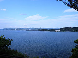
Lake Hamana
| Lake Hamana | |
|---|---|

A view from Hamanako Service Area
|
|

Landsat image
|
|
| Location | Shizuoka Prefecture |
| Coordinates | 34°44′28″N 137°34′11″E / 34.74111°N 137.56972°ECoordinates: 34°44′28″N 137°34′11″E / 34.74111°N 137.56972°E |
| Primary outflows | Philippine Sea |
| Basin countries | Japan |
| Surface area | 65.0 km² |
| Average depth | 4.8 meters |
| Max. depth | 16.6 meters |
| Water volume | 0.35 km³ |
| Shore length1 | 114 kilometers |
| Surface elevation | 0 meters |
| 1 Shore length is not a well-defined measure. | |
Lake Hamana (浜名湖 Hamana-ko?) in Shizuoka Prefecture is Japan's tenth-largest lake (by area). It spans the boundaries of the cities of Hamamatsu and Kosai.
The lake has an area of 65.0 km² and holds 0.35 km³ of water. Its circumference is 114 km. At its deepest point, the water is 16.6 m deep. The surface is at sea level.
Lake Hamana is a commercial source of cultivated Japanese eel, nori, oysters and Chinese soft-shelled turtles. Fishers take sea bass, whiting, and flounder, among others. The lake has been developed as a resort area, with boating as a feature.
In ancient times, Lake Hamana was a fresh-water lake. However, a great earthquake in 1498 altered the topography of the area. As a result, the water in the lake is now brackish.
The old name for this lake is Tohotsu-afumi (遠つ淡海?), which means "distant fresh-water lake" and later changed to Tōtōmi (遠江?). From the perspective of the capital in the Kinai, Tōtōmi is more distant than the other famous lake, Chikatsu-afumi or Ōmi (now Lake Biwa), the "nearby fresh-water lake." The name Tōtōmi was also used for a former province in which the lake is located (Tōtōmi Province).
...
Wikipedia
