Lake Gleneida
| Lake Gleneida | |
|---|---|

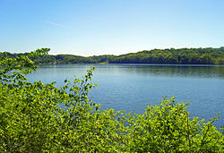
From east shore, looking south
|
|
| Location | Carmel Hamlet, New York |
| Coordinates | 41°25′12″N 73°41′00″W / 41.42000°N 73.68333°WCoordinates: 41°25′12″N 73°41′00″W / 41.42000°N 73.68333°W |
| Type | reservoir |
| Catchment area | 313.6 acres (126.9 ha) |
| Basin countries | United States |
| Max. length | 3,500 ft (1,100 m) |
| Max. width | 2,000 ft (610 m) |
| Surface area | 168 acres (68 ha) |
| Average depth | 48 ft (15 m) |
| Max. depth | approx. 100 ft (30 m) |
| Water volume | 8,042 acre·ft (9,920,000 m3) |
| Surface elevation | 505 ft (154 m) |
| References | |
Lake Gleneida is a controlled lake in Carmel, New York, United States. It is part of New York City's water supply system, created when an original pond was dammed in 1870.
The roughly heart-shaped lake is immediately to the southwest of downtown Carmel. Its 168 acres (68 ha) are surrounded by grassy parkland sloping down to the lake from the roads on the south and east, and woods on the other sides. NY 301 follows the north shore, ascending to its eastern terminus at NY 52 across from the Putnam County courthouse. Route 52 follows the eastern shore for a short distance to the south of this intersection before it, too, ends at US 6, which continues around the southern shore. There is no road along the western side, although a local street, Glenvue Drive, traverses the top of the 545-foot (166 m)-high ridge there.
The lake fills a small depression in the middle of a hilly area. Its bottom continues its rapid drop from the shoreline, reaching a depth of slightly over 100 feet (30 m) in the middle of the lake, equivalent to the surface of a swampy depression to its east. Mean depth is 48 feet (15 m). It typically contains 8.042 acre feet (9,920 m3), or 2.6 billion US gallons (9,800,000 m3) of water.
There are no inlet brooks, as the lake was originally a pond. A small, unnamed outlet brook drains from the northwest, emptying in less than a thousand feet (300 m) to West Branch Reservoir. Water not impounded and delivered to the city from there follows the Croton River to the Hudson.
The lake was originally known as Shaw's Pond, after an early landowner. It had been a part of the Carmel landscape since the hamlet's designation as county seat upon Putnam's 1814 creation. It quickly became a popular spot for boating and fishing.
...
Wikipedia
