Lake Creek (Siuslaw River)
| Lake Creek | |
|
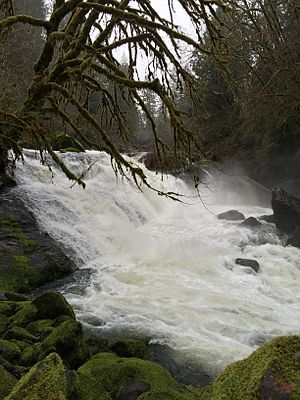
Lake Creek Falls near Triangle Lake
|
|
| Name origin: For Triangle Lake | |
| Country | United States |
|---|---|
| State | Oregon |
| County | Lane |
| Source | near Prairie Mountain |
| - location | Central Oregon Coast Range, Siuslaw National Forest |
| - elevation | 2,752 ft (839 m) |
| - coordinates | 44°16′43″N 123°34′18″W / 44.27861°N 123.57167°W |
| Mouth | Siuslaw River |
| - location | Swisshome |
| - elevation | 112 ft (34 m) |
| - coordinates | 44°03′19″N 123°47′47″W / 44.05528°N 123.79639°WCoordinates: 44°03′19″N 123°47′47″W / 44.05528°N 123.79639°W |
| Length | 40 mi (64.4 km) |
| Basin | 223 sq mi (578 km2) |
| Discharge | |
| - average | 706 cu ft/s (20 m3/s) |
Lake Creek is a major tributary of the Siuslaw River in Lane County in the U.S. state of Oregon. On average, the 40-mile (64 km) long creek contributes about a third of the lower Siuslaw's water volume.
Beginning near Prairie Mountain near the Lane–Benton county border in the Central Oregon Coast Range, Lake Creek flows generally southeast through the Siuslaw National Forest to the vicinity of Horton, then southwest through the communities of Blachly, Triangle Lake, Greenleaf, and Deadwood. It enters the Siuslaw River at Swisshome, 29 miles (47 km) by water from the larger stream's mouth on the Pacific Ocean at Florence.
Oregon Route 36 runs along the creek from Blachly to Swisshome. Near Greenleaf, a covered bridge known as Lake Creek Bridge or Nelson Mountain Bridge carries Nelson Mountain Road over the creek. Nelson Road meets Route 36 just north of the bridge. The bridge is on the National Register of Historic Places.
The Bureau of Land Management oversees the Lake Creek Falls recreation site downstream of Triangle Lake. Open all year, the site is used for picnicking, swimming, and viewing runs of steelhead and coho and Chinook salmon as they travel upstream to spawn. The BLM added a fish ladder at this site in 1989; it opened 110 miles (180 km) additional stream-miles to migrating fish.
...
Wikipedia


