Siuslaw National Forest
| Siuslaw National Forest | |
|---|---|
|
IUCN category V (protected landscape/seascape)
|
|

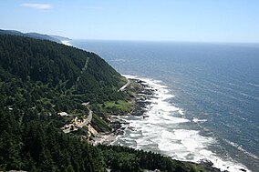
Cape Perpetua on the Lincoln County coast
|
|
| Location | Oregon, United States |
| Nearest city | Corvallis, Oregon |
| Coordinates | 44°20′00″N 123°55′00″W / 44.33333°N 123.91667°WCoordinates: 44°20′00″N 123°55′00″W / 44.33333°N 123.91667°W |
| Area | 634,207 acres (2,566.54 km2) |
| Established | July 1, 1908 |
| Visitors | 1,856,000 (in 2006) |
| Governing body | United States Forest Service |
| Website | Siuslaw National Forest |
The Siuslaw National Forest (/saɪˈjuːslɔː/ sy-EW-slaw) is a national forest in western Oregon in the United States. Established in 1908, the Siuslaw is made up of a wide variety of ecosystems, ranging from coastal forests to sand dunes.
The Siuslaw National Forest encompasses more than 630,000 acres (2,500 km2) along the central Oregon Coast between Coos Bay and Tillamook, and in some places extends east from the ocean, beyond the crest of the Oregon Coast Range, almost reaching the Willamette Valley. The forest lies primarily in Lane County (39% of the forest) and Lincoln County (27% of the forest); the rest in descending order of land area are Tillamook, Douglas, Yamhill, Benton, Coos, and Polk counties. It includes the Sand Lake Recreation Area and the Oregon Dunes National Recreation Area. The Forest Supervisor's office is located in Corvallis, and the Siuslaw is broken up into two ranger districts—the Hebo Ranger District, with approximately 151,000 acres (610 km2), and the Central Coast Ranger District, with approximately 479,000 acres (1,940 km2).
...
Wikipedia

