Lake Cargelligo railway station, New South Wales
|
Lake Cargelligo New South Wales |
|
|---|---|

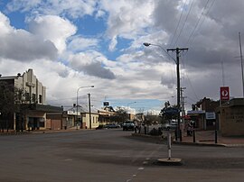
Main street
|
|
| Coordinates | 33°18′0″S 146°22′0″E / 33.30000°S 146.36667°ECoordinates: 33°18′0″S 146°22′0″E / 33.30000°S 146.36667°E |
| Population | 1,380 (2011 census) |
| Postcode(s) | 2672 |
| Location |
|
| LGA(s) | Lachlan Shire |
| State electorate(s) | Barwon |
| Federal Division(s) | Parkes |
Lake Cargelligo (/ˌleɪk kɑːrˈdʒɛlɪɡoʊ/, locally [ˌlæɪk kaːˈdʒeləɡəʉ]) is a town in the Central West region of New South Wales, Australia, on Lake Cargelligo. It is in Lachlan Shire. At the 2011 census, Lake Cargelligo had a population of 1,380 people. Its name is said to be a corruption of the Aboriginal word 'Kartjellakoo' meaning 'he had a coolamon'. A coolamon is a shallow wooden dish. Alternatively it is derived from Wiradhuri and Ngiyambaa "gajal" for water container with suffix "lugu" for "her" or "his". In 2011 it had an indigenous population of 236 (17.1%) and an Australian born population of 1,241 (89.7%).
The explorers, John Oxley and George Evans, followed the Lachlan River down to Lake Cargelligo in 1817. Lake Cargelligo was known as Cudgelligo (or sometimes Cudgellico) in the 1800s and was officially changed when the railway arrived in 1917.
The railway from Cootamundra to Wyalong was extended to Lake Cargelligo in 1917. The railway station opened as 'Cargelligo' in 1917 and was renamed 'Lake Cargelligo' in 1919. Rail-motor passenger services operated to the town until 1983. Since then the railway link has been used for cargo transport, especially for bulk grain which the surrounding farms cultivate. It also has a strong World War I background and ANZAC heritage.
...
Wikipedia

