Lake Boon
| Lake Boon | |
|---|---|

Lake Boon
|
|
| Location | Stow and Hudson, Massachusetts |
| Coordinates | 42°24′11″N 71°30′05″W / 42.40306°N 71.50139°WCoordinates: 42°24′11″N 71°30′05″W / 42.40306°N 71.50139°W |
| Primary outflows | Assabet River |
| Catchment area | 1,690 acres (680 ha) |
| Basin countries | United States |
| Max. length | 1.5 mi (2.4 km) |
| Surface area | 163 acres (66 ha) |
| Average depth | 10.7 ft (3.3 m) |
| Max. depth | 23 ft (7.0 m) |
| Settlements | Stow, Hudson |
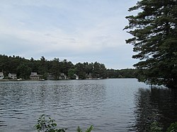
Lake Boon is a lake in eastern Massachusetts covering about 163 acres (0.66 km2) in the towns of Stow and Hudson, Massachusetts. It has been an important part of the Stow and Hudson communities since the towns originated. It was originally named Boon Pond after Matthew Boon, an explorer from Charlestown, Massachusetts who came to the area in 1660. He was the first of two settlers in Stow and was killed by Native Americans near the Lake on about February 14, 1676. In 1883 a monument was erected in memory of him.
September 4, 1851, Thoreau's journal entry is titled "A Walk to Boon's Pond in Stow." It starts out "Sept. 4. 8 A. M. A clear and pleasant day after the rain. Start for Boon's Pond in Stow with C." [William Ellery Channing] Of the 2,800 word entry for that day, very little is actually about the pond: "And now we leave the road and go through the woods and swamps toward Boon's Pond, crossing two or three roads and by Potter's house in Stow; still on east of river... Part of it called Boon's Plain. Boon said to have lived on or under Bailey's Hill at west of pond. Killed by Indians between Boon's and White's Pond as he was driving his ox-cart. The oxen ran off to Marlborough garrison-house. His remains have been searched for. A sandy plain, a large level tract. The pond shores handsome enough, but water shallow and muddy looking. Well-wooded shores. The maples begin to show red about it. Much fished."
The lake consists of four basins. The first basin made up the original part of the lake. It is the largest basin of the four and stretches from "the Narrows" to the dam on Barton Road in Stow. It is the only part of the lake that is completely in Stow. In 1847 the water rights to Boon Pond were purchased by Amory Maynard and a dam was built to increase the size of the pond. The intent was to add to the water reserve needed to provide continuous water power to the Assabet Woolen Mill, in the town of Maynard. Thus, in the early years the pond would be large after the spring melt, then shrink as water was let out during the summer months. Once the woolen mill converted to coal-fired steam power the need for Lake Boon's water was ended, and a more permanent water level was established.
The expansion went into the Ramshorn Meadow and the Ramshorn Swamp. The meadow area is now known as the second basin, while the swamp area is known as the third and fourth basins. The expansion helped locals to recognize this body of water no longer as a pond, but as a lake. Boon Lake is now 163 acres (0.66 km2) in size and one and a half miles long. Maximum depth of the first basin is 23 ft (7.0 m), the deepest part of the lake. The second basin is only 10 ft (3.0 m) deep, the third basin is a mere 7 ft (2.1 m) deep, and the fourth basin is 4 ft (1.2 m) deep.
...
Wikipedia
