Lake Billy Chinook
| Lake Billy Chinook | |
|---|---|

Lake Billy Chinook
|
|
| Location | Jefferson County, Oregon |
| Coordinates | 44°35′21″N 121°21′54″W / 44.58912°N 121.36496°WCoordinates: 44°35′21″N 121°21′54″W / 44.58912°N 121.36496°W |
| Type | Reservoir |
| Primary inflows | Crooked, Deschutes, and Metolius rivers |
| Primary outflows | Deschutes River |
| Catchment area | 7,514 square miles (19,500 km2) |
| Basin countries | United States |
| Max. length | 28 mi (45 km) |
| Surface area | 4,000 acres (1,600 ha) |
| Average depth | 102 ft (31 m) |
| Max. depth | 415 ft (126 m) |
| Shore length1 | 72 mi (116 km) |
| Surface elevation | 1,945 ft (593 m) |
| Islands | Chinook Island |
| Settlements | Culver |
| 1 Shore length is not a well-defined measure. | |
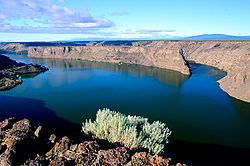
Lake Billy Chinook is a reservoir in Jefferson County in the U.S. state of Oregon. Created by the Round Butte Dam in 1964, Lake Billy Chinook lies in a canyon at the confluence of the Crooked, Deschutes, and Metolius rivers near Culver and Madras. It was named for Billy Chinook, a Native American of the Wasco tribe who traveled alongside American explorers John C. Frémont and Kit Carson in their expeditions of 1843 and 1844.
The canyon in which Lake Billy Chinook lies was carved by the three rivers that flow into the lake. The Deschutes Formation into which it is carved began forming about 11 million years ago, as alternating layers of basaltic lava, stream sediment, and volcanic debris flowed into the area from the Cascade Range. One to three million years ago, lava flows from the Cascades and Newberry Volcano capped the exposed material, forming the "rimrock basalt" which is visible atop the canyon. Further erosion by the three rivers, volcanic activity, and wind have continued to form and erode the canyon.
The Deschutes and Crooked River branches of the lake are within the boundaries of The Cove Palisades State Park. The south shores of the Metolius River are public lands administered by the Bureau of Land Management and the United States Forest Service, while the north shores are part of the Warm Springs Indian Reservation. Along with the Island peninsula, there is one island in the lake named Chinook Island.
...
Wikipedia
