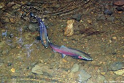
Lagunitas Creek
| Lagunitas Creek (Tokelalume) | |
| Paper Mill Creek | |
| stream | |
|
Pair of endangered coho salmon in Lagunitas Creek.
|
|
| Name origin: Spanish | |
| Country | United States |
|---|---|
| State | California |
| Region | Marin County |
| Tributaries | |
| - left | Olema Creek |
| - right | Devils Gulch, San Geronimo Creek, Nicasio Creek |
| Source | Mount Tamalpais |
| - coordinates | 37°56′51″N 122°35′50″W / 37.94750°N 122.59722°W |
| Mouth | Tomales Bay |
| - elevation | 0 ft (0 m) |
| - coordinates | 38°4′48″N 122°49′37″W / 38.08000°N 122.82694°WCoordinates: 38°4′48″N 122°49′37″W / 38.08000°N 122.82694°W |
| Length | 20 mi (32 km) |
| Basin | 103 sq mi (267 km2) |
Lagunitas Creek is a 20 miles (32 km)-long northward-flowing stream in Marin County, California. It is critically important to the largest spawning runs of endangered coho salmon (Oncorhynchus kistuch) in the Central California Coast Coho salmon Evolutionary Significant Unit (CCC ESU). The stream's headwaters begin on the northern slopes of Mt. Tamalpais in the Coast Range and terminate in southeast Tomales Bay, 1.5 miles (2.4 km) northwest of Point Reyes Station, California. Lagunitas Creek feeds several reservoirs on Mt. Tamalpais that supply a major portion of the county's drinking water.
To the Coast Miwok the stream was known as Tokelalume, then by the Spanish as Arroyo de San Geronimo. Now the "San Geronimo" survives only as the San Geronimo Creek tributary. The modern name, Lagunitas Creek, is derived from the several "lagunitas" (Spanish for "little lakes") which have now been turned into reservoirs by dams in the upper watershed. It was once known as Paper Mill Creek because Samuel P. Taylor built a paper mill on the creek in Taylorville. This mill, the Pioneer Paper Mill, was built in 1856, the first in California.
Lagunitas Creek's major tributaries include San Geronimo Creek, Devils Gulch, Nicasio Creek, and Olema Creek. The creek's source is the northern slope of Mount Tamalpais, a few miles (~6–8 km) east of Bolinas Lagoon. The creek begins as three forks, the East Fork, Middle Fork and West Fork. After about a mile (1,600 m), they all flow into Lake Lagunitas, which drains into Bon Tempe Lake, which drains into Alpine Lake. Downstream of Alpine Lake, the creek flows roughly northwest until it reaches Kent Lake. Just downstream of Kent Lake, San Geronimo Creek joins the creek. Lagunitas continues northwest through Samuel P. Taylor State Park and is joined by Nicasio Creek, which flows from Nicasio Reservoir, another water storage reservoir. Shortly after this confluence, Lagunitas turns westward and flows through the town of Point Reyes Station. On the west side of the town, the creek is joined by Olema Creek, the largest tributary in the Lagunitas Creek watershed. Olema Creek receives Bear Valley Creek, and mainstem Olema Creek flows for 9 miles (14 km) along the San Andreas Fault Zone, with a catchment area of 14.5 square miles (38 km2). After receiving the waters of Olema Creek, Lagunitas Creek turns northward and then empties into the wetlands at the southeast end of Tomales Bay.
...
Wikipedia

