
Laer
| Laer | ||
|---|---|---|
|
||

Laer
|
||
|
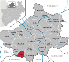
Location of Laer within Steinfurt district
  |
||
| Coordinates: 52°03′17″N 7°21′25″E / 52.05472°N 7.35694°ECoordinates: 52°03′17″N 7°21′25″E / 52.05472°N 7.35694°E | ||
| Country | Germany | |
| State | North Rhine-Westphalia | |
| Admin. region | Münster | |
| District | Steinfurt | |
| Government | ||
| • Mayor | Peter Maier (SPD) | |
| Area | ||
| • Total | 35.05 km2 (13.53 sq mi) | |
| Elevation | 77 m (253 ft) | |
| Population (2015-12-31) | ||
| • Total | 6,721 | |
| • Density | 190/km2 (500/sq mi) | |
| Time zone | CET/CEST (UTC+1/+2) | |
| Postal codes | 48366 | |
| Dialling codes | 02554 | |
| Vehicle registration | ST | |
| Website | www.laer.de | |

Laer is a municipality in the district of Steinfurt, in North Rhine-Westphalia, Germany. It is situated approximately 10 kilometres (6.2 mi) south of Steinfurt and 20 kilometres (12 mi) north-west of Münster.
Laer, church (Pfarrkirche Sankt Bartholomäus)
Laer, chapel in the street
Holthausen, church (Pfarrkirche Sankt Marien)
Altenburg, street view from local road
...
Wikipedia