Ladd's Addition
|
Ladd's Addition Historic District
|
|

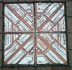
Brick map of Ladd's Addition at the corner of SE 34th Avenue and SE Madison Street
|
|
| Location | Portland, Oregon |
|---|---|
| Coordinates | 45°30′31″N 122°38′58″W / 45.508539°N 122.649413°WCoordinates: 45°30′31″N 122°38′58″W / 45.508539°N 122.649413°W |
| Area | 126 acres (0.51 km2) |
| Built | 1905–1930 |
| MPS | |
| NRHP reference # | 88001310 |
| Added to NRHP | August 31, 1988 |
Ladd's Addition is an inner southeast historic district of Portland, Oregon, United States. It is Portland's oldest planned residential development, and one of the oldest in the western United States. The district is known in Portland for a diagonal street pattern, which is at odds with the rectilinear grid of the surrounding area. Roughly eight blocks (east-west) by ten blocks (north-south) in size (by reference to the surrounding grid), Ladd's is bordered by SE Hawthorne, Division, 12th, and 20th streets. It is part of the Hosford-Abernethy neighborhood association.
Ladd's Addition is named after William S. Ladd, a merchant and mid-19th-century Portland mayor who owned a 126-acre (51 ha) farm on the land. In 1891 (when the city of East Portland was merged into Portland) Ladd subdivided the land for residential use. Rather than follow the standard orthogonal grid of the surrounding area, Ladd, inspired by the L'Enfant Plan for Washington, D.C., created a diagonal "wagon wheel" arrangement, including four small diamond-shaped rose gardens and a central traffic circle surrounding a park. It is also one of the few areas in Portland with alleys, with street elevations mostly uninterrupted by curb cuts.
The homes in the district, mostly developed between 1905 and 1930 (after Ladd's death), have been called a "architecturally rich mix of compatible early 20th century styles", notable for their "continuity of scale, setback, orientation, and materials."Architectural styles represented include bungalow, craftsman, American Foursquare, Mission, Tudor, and Colonial Revival.
...
Wikipedia
