Lac Mistassini
| Lake Mistassini | |
|---|---|

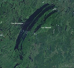
Satellite image of Lakes Mistassini and Albanel
|
|
| Location | Baie-James, Jamésie Territory, Quebec |
| Coordinates | 50°57′N 73°42′W / 50.950°N 73.700°WCoordinates: 50°57′N 73°42′W / 50.950°N 73.700°W |
| Type | Oligotrophic |
| Primary inflows | various rivers |
| Primary outflows | Rupert River |
| Catchment area | 1,813 km2 (700 sq mi) |
| Basin countries | Canada |
| Max. length | 161 km (100 mi) |
| Max. width | 19 km (12 mi) |
| Surface area | 2,335 km2 (902 sq mi) |
| Max. depth | 183 m (600 ft) |
| Water volume | 150 km3 (36 cu mi) |
| Surface elevation | 372 m (1,220 ft) |
| Islands | Pahipanouk Tchapahipane |
Lake Mistassini (in French: Lac Mistassini) is the largest natural lake by surface area in the province of Quebec, Canada, with a total surface area of approximately 2,335 km² and a net area (water surface area only) of 2,164 km². It is located in the Jamésie region of the province, approximately 360 kilometers (220 mi) east of James Bay. The Cree town of Mistissini is located on Watson Peninsula in the south-east corner of the lake, which separates Baie du Poste from Abatagouche Bay. Extensive forests of Spruce, Birch, Pine, and Fir trees, which support a booming forestry industry, surround the lake.
Significant tributaries flowing into the lake include: Chalifour, Pépeshquasati, Takwa, Témiscamie, and Wabissinane.
Other nearby lakes include Lake Troilus.
In 2016, it was reported that the arc shaped lake, together with nearby Lake Albanel, may have been formed by a large meteor impact about 2.1 billion years ago. The rest of the 500 km diameter crater is thought to have now been mostly eroded away or buried but geological indications of a major impact have been found in the rocks around the lake. If confirmed this would be the largest impact crater found on the earth.
The name Mistassini came from the Cree mista assini or Montagnais mishta ashini, and means large rock; it probably refers a large glacial erratic stone, about 3 meters (9.8 ft) high, located near the outlet of Lake Mistassini into the Rupert River.
Over the centuries, it went through many name changes and different spellings. In 1664, on a map by Ducreux, this lake was known as Outakgami. On maps by Jolliet (1684), Jaillot (1685) and Franquelin (1688), the lake was identified as Timagaming. In 1703, the cartographer Guillaume Delisle used the same name, along with the name Mistasin. Laure (1731) and Bellin (1744) showed on their maps the name Lake Mistassins. Other spelling variations of this Native American designation included: Mistacinnee, Mistacsinney, Mistasinne, Mistasinia, etc.
...
Wikipedia

