La Salle Parish, Louisiana
| LaSalle Parish, Louisiana | |
|---|---|

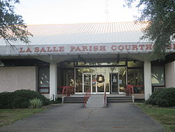
La Salle Parish Courthouse in Jena
|
|
 Location in the U.S. state of Louisiana |
|
 Louisiana's location in the U.S. |
|
| Founded | January 1, 1910 |
| Named for | René-Robert Cavelier, Sieur de La Salle |
| Seat | Jena |
| Largest town | Jena |
| Area | |
| • Total | 662 sq mi (1,715 km2) |
| • Land | 625 sq mi (1,619 km2) |
| • Water | 38 sq mi (98 km2), 5.7% |
| Population (est.) | |
| • (2015) | 14,974 |
| • Density | 24/sq mi (9/km²) |
| Congressional district | 5th |
| Time zone | Central: UTC-6/-5 |
LaSalle Parish (French: Paroisse de La Salle) is a parish located in the U.S. state of Louisiana. As of the 2010 census, the population was 14,890. The parish seat is Jena. The parish was created in 1910 from the western section of Catahoula Parish and named for René-Robert Cavelier, Sieur de La Salle.
According to the U.S. Census Bureau, the parish has a total area of 662 square miles (1,710 km2), of which 625 square miles (1,620 km2) is land and 38 square miles (98 km2) (5.7%) is water.
As of the census of 2000, there were 14,282 people, 5,291 households, and 3,798 families residing in the parish. The population density was 23 people per square mile (9/km²). There were 6,273 housing units at an average density of 10 per square mile (4/km²). The racial makeup of the parish was 86.13% White, 12.20% Black or African American, 0.64% Native American, 0.18% Asian, 0.01% Pacific Islander, 0.20% from other races, and 0.64% from two or more races. 0.82% of the population were Hispanic or Latino of any race.
...
Wikipedia
