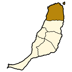
La Oliva
| La Oliva | |||
|---|---|---|---|
| Municipality | |||
|
|||
 Location in Fuerteventura |
|||
| Location in Canary Islands | |||
| Coordinates: 28°36′40″N 13°55′40″W / 28.61111°N 13.92778°WCoordinates: 28°36′40″N 13°55′40″W / 28.61111°N 13.92778°W | |||
| Country | Spain | ||
| Autonomous Community | Canary Islands | ||
| Province | Las Palmas | ||
| Island | Fuerteventura | ||
| Area | |||
| • Total | 356.13 km2 (137.50 sq mi) | ||
| Population (2013) | |||
| • Total | 25,083 | ||
| • Density | 70/km2 (180/sq mi) | ||
La Oliva (pronounced: [la oliˈβa]) is a town and a municipality in the northern part of the island of Fuerteventura in the Province of Las Palmas, Canary Islands, Spain. The population is 25,083 (2013), and the area is 356.13 km². The municipality includes the Lobos Island to the northeast. The largest town of the municipality, Corralejo, is a port town and beach resort at the northernmost point of the island. La Oliva is the historic seat of the island Colonel, who resided in the stately Casa de los Coroneles.
"Montaña Quemada" Canyon
A stone-built windmill near the beach of La Oliva
Church of Our Lady of La Candelaria
Corralejo beach
Los Lobos Island
...
Wikipedia


