La Brévine
| La Brévine | ||
|---|---|---|

View of La Brévine
|
||
|
||
| Coordinates: 46°59′N 6°36′E / 46.983°N 6.600°ECoordinates: 46°59′N 6°36′E / 46.983°N 6.600°E | ||
| Country | Switzerland | |
| Canton | Neuchâtel | |
| District | Le Locle | |
| Area | ||
| • Total | 41.82 km2 (16.15 sq mi) | |
| Elevation | 1,043 m (3,422 ft) | |
| Population (Dec 2015) | ||
| • Total | 642 | |
| • Density | 15/km2 (40/sq mi) | |
| Postal code | 2406 | |
| SFOS number | 6432 | |
| Surrounded by | Boveresse, Couvet, Grand'Combe-Châteleu (FR-25), Hauterive-la-Fresse (FR-25), La Chaux-du-Milieu, Le Cerneux-Péquignot, Les Bayards, Les Gras (FR-25), Les Ponts-de-Martel, Montbenoît (FR-25), Saint-Sulpice, Travers, Ville-du-Pont (FR-25) | |
| Twin towns | Leynes (France) | |
| Website |
www SFSO statistics |
|
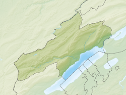
La Brévine is a municipality in the district of Le Locle in the canton of Neuchâtel in Switzerland. The village's microclimate is often much colder than other nearby locations. On 12 January 1987, the local weather station recorded a temperature of −41.8 °C (−43.2 °F), the coldest ever recorded in Switzerland.
In the 17th century, La Brévine was used to refer to just the village. It wasn't until the 18th century that it came to mean the entire municipality. The hamlet of Bémont is first mentioned in 1266 as Bemont, and Les Taillères was first mentioned in 1304 as Chaul de Estaleres.
La Brévine has an area, as of 2009[update], of 41.8 square kilometers (16.1 sq mi). Of this area, 22.41 km2 (8.65 sq mi) or 53.6% is used for agricultural purposes, while 17.76 km2 (6.86 sq mi) or 42.5% is forested. Of the rest of the land, 0.97 km2 (0.37 sq mi) or 2.3% is settled (buildings or roads), 0.42 km2 (0.16 sq mi) or 1.0% is either rivers or lakes and 0.4 km2 (0.15 sq mi) or 1.0% is unproductive land.
Of the built up area, housing and buildings made up 1.3% and transportation infrastructure made up 0.9%. Out of the forested land, 37.5% of the total land area is heavily forested and 4.9% is covered with orchards or small clusters of trees. Of the agricultural land, 0.3% is used for growing crops and 32.9% is pastures and 20.4% is used for alpine pastures. All the water in the municipality is in lakes.
The municipality is located in the Le Locle district, near the French border. It consists of the village of La Brévine (elevation 1,046 m [3,432 ft]) and the hamlets of Le Brouillet, Bémont, Les Taillères and La Châtagne as well as scattered farm houses.
Lac des Taillères is located 2 km (1.2 mi) from the village.
The blazon of the municipal coat of arms is Azure bordered Or, a Fountain Argent.
...
Wikipedia


