La Banda
| La Banda | |
|---|---|
| City | |
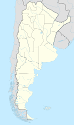
| Location of La Banda in Argentina | |
| Coordinates: 27°44′S 64°15′W / 27.733°S 64.250°WCoordinates: 27°44′S 64°15′W / 27.733°S 64.250°W | |
| Country |
|
| Province | Santiago del Estero |
| Department | Banda |
| Founded | September 16, 1912 |
| Elevation | 191 m (627 ft) |
| Population (2010) | |
| • Total | 106,441 |
| Time zone | ART (UTC-3) |
| CPA base | G4300 |
| Dialing code | +54 385 |
| Climate | BSh |
| Website | http://www.labanda.gov.ar/ |
La Banda is a city in the province of Santiago del Estero, Argentina. It has about 95,000 inhabitants as per the 2001 census [INDEC], making it the second largest in the province. It is the head town of the Banda Department.
La Banda is located only 8 km away from the provincial capital Santiago del Estero, separated from it by the course of the Dulce River, which is crossed by two connecting bridges. The two cities form a metropolitan area with about 280,000 inhabitants. Close to it, the Dulce is turned into an artificial lake by the Los Quiroga Dam.
Besides the access to National Route 9 through Santiago del Estero, the city is linked to Tucumán and to Buenos Aires by a weekly train service of the Ferrocarril General Bartolomé Mitre.
La Banda is the birthplace of the infamous former provincial governor and caudillo Carlos Juárez.
La Banda emerged during the nineteenth century as a small agricultural town that supplied the neighboring city of Santiago del Estero. On September 16, 1912 La Banda was elevated to city status.
The first Maternity Hospital in La Banda was built by Decree No. 928 Series, dated 1941.
...
Wikipedia

