Lạng Sơn Province
|
Lạng Sơn Province Tỉnh Lạng Sơn |
|
|---|---|
| Province | |
 |
|
 Location of Lạng Sơn within Vietnam |
|
| Coordinates: 21°45′N 106°30′E / 21.750°N 106.500°ECoordinates: 21°45′N 106°30′E / 21.750°N 106.500°E | |
| Country |
|
| Region | Northeast |
| Capital | Lạng Sơn |
| Area | |
| • Total | 8,327.6 km2 (3,215.3 sq mi) |
| Population (2008) | |
| • Total | 759,000 |
| • Density | 91/km2 (240/sq mi) |
| Demographics | |
| • Ethnicities | Vietnamese, Tày, Dao, Nùng |
| Time zone | ICT (UTC+7) |
| Calling code | 25 |
| ISO 3166 code | VN-09 |
| Website | www |
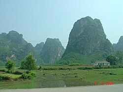
Lạng Sơn (![]() listen) is a province in far northern Vietnam, bordering Guangxi province in China. Its capital is also called Lạng Sơn, which is a strategically important town at the border with China and is 137 kilometres (85 mi) northeast of Hanoi connected by rail and road. Lạng Sơn Province is bounded by China in the north, Cao Bằng Province borders the northwest, Ha Bac Province to the south, Quảng Ninh Province starting on the south and extending to the eastern border and Thái Nguyên Province to the west. The province covers an area of 8,327.6 square kilometres and as of 2008 it had a population of 759,000 people.
listen) is a province in far northern Vietnam, bordering Guangxi province in China. Its capital is also called Lạng Sơn, which is a strategically important town at the border with China and is 137 kilometres (85 mi) northeast of Hanoi connected by rail and road. Lạng Sơn Province is bounded by China in the north, Cao Bằng Province borders the northwest, Ha Bac Province to the south, Quảng Ninh Province starting on the south and extending to the eastern border and Thái Nguyên Province to the west. The province covers an area of 8,327.6 square kilometres and as of 2008 it had a population of 759,000 people.
Lạng Sơn Province, Hà Giang, Lào Cai, Bắc Giang, Bắc Kạn, Cao Bằng, Phú Thọ, Quảng Ninh, Thái Nguyên, Tuyên Quang and Yên Bái of the Northeast (Đông Bắc) region) are all part of the 59 administrative provinces and 5 municipalities in Vietnam.
...
Wikipedia
