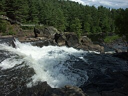
L'Assomption River
| L'Assomption River | |
| Rivière L'Assomption | |
|
Assomption River at Chutes Monte-à-Peine Park in Matawinie Regional County Municipality
|
|
| Country | Canada |
|---|---|
| Province | Quebec |
| Region | Lanaudière |
| Source | Lac de l'Assomption |
| - location | Saint-Guillaume-Nord |
| - coordinates | 46°27′45″N 74°03′16″W / 46.46250°N 74.05444°W |
| Mouth | Rivière des Prairies |
| - location | Repentigny |
| - coordinates | 45°42′52″N 73°28′51″W / 45.71444°N 73.48083°WCoordinates: 45°42′52″N 73°28′51″W / 45.71444°N 73.48083°W |
| Length | 200 km (120 mi) |
The Assomption River (in French Rivière l'Assomption, named after the Assumption of Mary) is the most important waterway in the Lanaudière region of Quebec, Canada, is over 200 kilometres (120 mi) long, and has a drainage basin of 4,220 square kilometres (1,630 sq mi). Its source is the Mont Tremblant massif. Seven significant rivers flow into the Assomption (de la Boule, Versailles, Noire, la Chaloupe, Ouareau, Saint-Esprit, and Achigan) before it flows into the Rivière des Prairies at Repentigny, Quebec.
About 150,000 people live in the drainage area of this river.
The L'Assomption River watershed overlaps two natural environments, the Laurentian Mountains and the St-Lawrence lowlands, which cover about a third of the watershed area. Its relief is a uniform plain with some hills—from 0 to 100 metres (0 to 328 ft)—dominated by agricultural lands. The texture of the soil is rather fine and rests on an impermeable argillaceous (clay) base.
The Laurentian Mountains form part of the Canadian Shield. They are separated from the lowlands by a well defined escarpment that rises about 150 metres (490 ft). This escarpment has many waterfalls. The Laurentians Mountains have an average height of 230 metres (750 ft) in the south and 460 metres (1,510 ft) in the north. And there are even mountains of over 600 metres (2,000 ft) in the Mont Tremblant massif where the L'Assomption River forms.
From north to south the average slope of the river decreases. The steeper slopes of the highlands create a fast current whereas the lowland flats produces a slower flow. Moreover, the river meanders a lot which is especially evident at the town of L'Assomption, almost completely surrounded by a large loop of the river.
The L'Assomption River watershed has 490 lakes of which 24 have a surface area larger than 1 square kilometre (250 acres). Most of the lakes are in the Laurentian highlands.
...
Wikipedia


