Kzyl Orda
|
Kyzylorda Қызылорда Qızılorda |
||
|---|---|---|
|
||
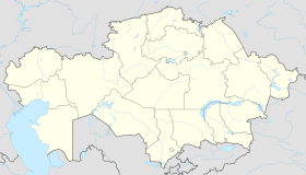
| Location in Kazakhstan | ||
| Coordinates: 44°51′0″N 65°31′0″E / 44.85000°N 65.51667°E | ||
| Country | Kazakhstan | |
| Region | Kyzylorda Region | |
| Founded | 1820 | |
| City status | 1867 | |
| Government | ||
| • Akim (mayor) | Nurlybek Nalibeav | |
| Area | ||
| • Total | 2,400 km2 (900 sq mi) | |
| Elevation | 128 m (420 ft) | |
| Population (2011) | ||
| • Total | 200,900 | |
| • Density | 84/km2 (220/sq mi) | |
| Time zone | ALMT (UTC+6) | |
| Postal code | 120001 - 120018 | |
| Area code(s) | +7 7242 | |
| Vehicle registration | N | |
| Website | www |
|
Coordinates: 44°51′N 65°31′E / 44.850°N 65.517°E
Kyzylorda (Kazakh: Қызылорда, Qızılorda قىزىلوردا), formerly known as Kzyl-Orda (Russian: Кзыл-Орда), Ak-Mechet (Russian: Ак-Мечеть), Perovsk (Russian: Перовск), and Fort-Perovsky (Russian: Форт-Перовский), is a city in south central Kazakhstan, capital of Kyzylorda Region and former capital of the Kazak ASSR from 1925 to 1929.
The city has a population of 157,400 (1999 Census). It historically developed around the Syr Darya River and the site of a Kokand fortress. Population: 188,682 (2009 Census results); 157,364 (1999 Census results).
Seljuk, the founder of the Seljuk dynasty, got his start near here. The city had its beginnings in 1820 as the site of a Kokand fortress known as Ak-Mechet, or white mosque. The later-famous Yaqub Beg was once the fort's commander, but he was apparently not in command during the final battle. In 1853, during the Russian conquest of Turkestan, the fort was taken by Russian troops under General Vasily Perovsky. The Russians established a new fort and called it Fort-Perovsky (Форт-Перо́вский), after the general.
...
Wikipedia


