Kyritz
| Kyritz | ||
|---|---|---|

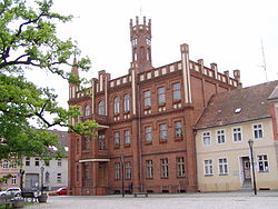
Town hall
|
||
|
||
| Coordinates: 52°57′00″N 12°24′00″E / 52.95000°N 12.40000°ECoordinates: 52°57′00″N 12°24′00″E / 52.95000°N 12.40000°E | ||
| Country | Germany | |
| State | Brandenburg | |
| District | Ostprignitz-Ruppin | |
| Government | ||
| • Mayor | Nora Görke (Ind.) | |
| Area | ||
| • Total | 156.09 km2 (60.27 sq mi) | |
| Population (2015-12-31) | ||
| • Total | 9,100 | |
| • Density | 58/km2 (150/sq mi) | |
| Time zone | CET/CEST (UTC+1/+2) | |
| Postal codes | 16866 | |
| Dialling codes | 03 39 71 | |
| Vehicle registration | OPR, KY, NP, WK | |
| Website | www.kyritz.de | |
Kyritz (German pronunciation: [ˈkyːʁɪts]) is a town in the Ostprignitz-Ruppin district, in Brandenburg, Germany. It is situated 28 km west of Neuruppin and 28 km southeast of Pritzwalk.
There are 9,900 inhabitants (2007).
The town is situated near the Kyritzer Seenkette, a chain of lakes. The town is nicknamed "Kyritz an der Knatter" (Kyritz at the Rattle). The noise of numerous water mills along a stream parallel to the river Jäglitz was the reason for this nickname. This river channel does not exist anymore.
The town includes the districts Berlitt, Bork, Drewen, Gantikow, Ganz, Holzhausen, Kötzlin, Lellichow, Mechow, Rehfeld and Teetz.
Development of population since 1875 within the current boundaries (Blue line: Population; Dotted line: Comparison to population development of Brandenburg state; Grey background: Time of Nazi rule; Red background: Time of communist rule)
Recent population development (blue line) and forecasts
Marketplace
Memorial stone
...
Wikipedia


