Kyneton
|
Kyneton Victoria |
|||||||||||||
|---|---|---|---|---|---|---|---|---|---|---|---|---|---|

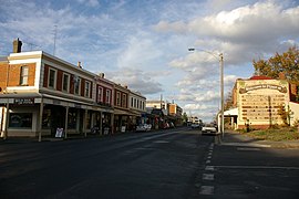
Looking along Piper Street, Kyneton
|
|||||||||||||
| Coordinates | 37°14′S 144°27′E / 37.233°S 144.450°ECoordinates: 37°14′S 144°27′E / 37.233°S 144.450°E | ||||||||||||
| Population | 6,629 (2011 census) | ||||||||||||
| Established | 1850 | ||||||||||||
| Postcode(s) | 3444 | ||||||||||||
| Elevation | 519 m (1,703 ft) | ||||||||||||
| Location |
|
||||||||||||
| LGA(s) | Shire of Macedon Ranges | ||||||||||||
| State electorate(s) | Macedon | ||||||||||||
| Federal Division(s) | Bendigo | ||||||||||||
|
|||||||||||||
|
|||||||||||||
Kyneton (/ˈkaɪntən/ KEYEN-tən) is a town in the Macedon Ranges region of Victoria, Australia. The Calder Freeway bypasses Kyneton to the north and east. The town was named after the English village of Kineton, Warwickshire.
The town has three main streets: Mollison Street, Piper Street and High Street. Piper Street has the oldest streetscape of these, and still has many of its original buildings. The railway station, about 91 kilometres (57 mi) from Melbourne on the Bendigo railway line, is a terminus for two weekday peak-hour trains. The town is the council seat of the Shire of Macedon Ranges. At the 2011 census, Kyneton had a population of 6,629.
Kyneton is home to mineral springs, the Campaspe River, botanical gardens and historic houses, many with bluestone architecture. Kyneton hosts several events during the year including the ANZAC Day parade, Kyneton Daffodil Festival, Kyneton Agricultural show and the Kyneton Cup.
Major Thomas Mitchell, an explorer, crossed and named the Campaspe River near present-day Kyneton on his 1836 expedition. The first British settlers arrived in the area the same year.
...
Wikipedia

