Kyōtamba, Kyoto
|
Kyōtamba 京丹波町 |
|||
|---|---|---|---|
| Town | |||

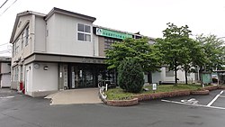
Kyōtamba Town hall
|
|||
|
|||
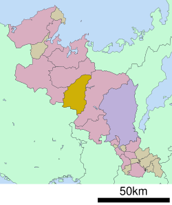
 Location of Kyōtamba in Kyoto Prefecture |
|||
| Location in Japan | |||
| Coordinates: 35°10′N 135°25′E / 35.167°N 135.417°ECoordinates: 35°10′N 135°25′E / 35.167°N 135.417°E | |||
| Country | Japan | ||
| Region | Kansai | ||
| Prefecture | Kyoto Prefecture | ||
| District | Funai | ||
| Area | |||
| • Total | 303.07 km2 (117.02 sq mi) | ||
| Population (April 1, 2017) | |||
| • Total | 14,770 | ||
| • Density | 49/km2 (130/sq mi) | ||
| Time zone | Japan Standard Time (UTC+9) | ||
| Website | www |
||
Kyōtamba (京丹波町? Kyōtanba-chō) is a town located in Funai District, Kyoto Prefecture, Japan. Its name comes from the first syllable of Kyōto and the former town of Tamba, a namesake of the historic Tamba Province.
As of April 2017, the town has an estimated population of 14,770. The total area is 303.07 km².
The town was founded on October 11, 2005 by the merger of the former towns of Tanba, Mizuho and Wachi, all from Funai District.
...
Wikipedia


