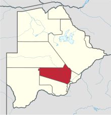
Kweneng District
| Kweneng | |
|---|---|
| District | |
 Location within Botswana |
|
| Coordinates: 24°00′S 25°00′E / 24.000°S 25.000°ECoordinates: 24°00′S 25°00′E / 24.000°S 25.000°E | |
| Country |
|
| Capital | Molepolole |
| Area | |
| • Total | 35,890 km2 (13,860 sq mi) |
| Population (2001 census) | |
| • Total | 230,335 |
| • Density | 6.4/km2 (17/sq mi) |
| Time zone | Central Africa Time (UTC+2) |
Kweneng is one of the districts of Botswana and is the recent historical homeland of the Bakwena people, the first group in Botswana converted to Christianity by famed missionary David Livingstone. Various landmarks, including Livingstone's Cave, allude to this history. The seat of the district's government is Molepolole, Botswana's most populous village (only trailing Botswana's two cities: Gaborone and Francistown).
It borders Central District in northeast, Kgatleng District on the east, South-East District in southeast, Southern District in south, Kgalagadi District in the west, Ghanzi District in the north. The district is administered by a district administration and district council which are responsible for local administration. Manyana rock paintings in Manyana village and Kgosi Sechele I Museum are the major attractions in the district.
As of 2011, the total population of the district was 304,549 compared to 230,335 in 2001. The growth rate of population during the decade was 2.83. As of 2006, the total number of people working in Kweneng East in agricultural sector was 7,212, 4,727 male and 2,484 female, with agriculture being the major profession.
Kweneng is the only district without a foreign border. It borders Central District in northeast, Kgatleng District on the east, South-East District in southeast, Southern District in south, Kgalagadi District in the west, Ghanzi District in the north. Kweneng borders more districts than any other district. The region is traversed by the northwesterly line of equal latitude and longitude. Most part of Botswana has tableland slopes sliding from east to west. The region has an average elevation of around 915 m (3,002 ft) above the mean sea level. The vegetation type is Savannah, with tall grasses, bushes and tress. The annual precipitation is around 25 cm (9.8 in), most of which is received during the summer season from November to May. Most of the rivers in the region are seasonal, with Limpopo River, which are prone to flash floods, being the most prominent. Manyana rock paintings in Manyana village and Kgosi Sechele I Museum are the major attractions in the district.
...
Wikipedia
