Kvarken
| Kvarken Archipelago | |
|---|---|
| Name as inscribed on the World Heritage List | |

Kvarken Archipelago in Finland, part of the High Coast/Kvarken Archipelago World Heritage Site
|
|
| Location | Finland |
| Type | Natural |
| Criteria | viii |
| Reference | 898 |
| UNESCO region | Europe and North America |
| Inscription history | |
| Inscription | 2000 (24th Session) |
| Extensions | 2006 |
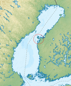
Kvarken (Swedish Kvarken or Norra Kvarken (as opposed to South Kvarken), Finnish Merenkurkku) is the narrow region in the Gulf of Bothnia separating the Bothnian Bay (the inner part of the gulf) from the Bothnian Sea. The distance from Swedish mainland to Finnish mainland is around 80 km (50 mi) while the distance between the outmost islands is only 25 km (16 mi). The water depth in the Kvarken region is only around 25 metres (82 ft). The region also has an unusual rate of land rising at about 10 mm (0.39 inches) a year.
On the Finnish side of Kvarken, there is a large archipelago, the Kvarken Archipelago, which includes the large islands Replot, Björkö and a large number of smaller islands. Most of it is belongs to the municipality of Korsholm. Most of the small islands are inhabited. The archipelago is smaller on the Swedish side of the region, and the islands have much steeper shores. The Kvarken region was historically important also, because mail was delivered across Kvarken when the sea was completely frozen from the Swedish to the Finnish coast. This mail route was used frequently during the period of Swedish rule.
In the group of islands in the “middle” of the Kvarken region, in Swedish called Valsörarna – Finnish Valassaaret, is a 36-metre-high (118 ft) lighthouse designed by Henry LePaute who worked for Gustave Eiffel's engineering bureau. The structural similarity between the lighthouse (built in 1885) and the Eiffel tower (built in 1889) is quite obvious. The lighthouse is now automated as are most lighthouses in Finland.
Coordinates: 63°30′N 21°0′E / 63.500°N 21.000°E
...
Wikipedia
