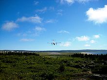
Kuujjuarapik Airport
| Kuujjuarapik Airport | |||||||||||
|---|---|---|---|---|---|---|---|---|---|---|---|
 |
|||||||||||
| Summary | |||||||||||
| Airport type | Public | ||||||||||
| Operator | Administration régionale Kativik | ||||||||||
| Serves | Kuujjuarapik, Whapmagoostui | ||||||||||
| Location | Kuujjuarapik | ||||||||||
| Time zone | EST (UTC−05:00) | ||||||||||
| • Summer (DST) | EDT (UTC−04:00) | ||||||||||
| Elevation AMSL | 40 ft / 12 m | ||||||||||
| Coordinates | 55°16′55″N 077°45′55″W / 55.28194°N 77.76528°WCoordinates: 55°16′55″N 077°45′55″W / 55.28194°N 77.76528°W | ||||||||||
| Map | |||||||||||
| Location in Quebec | |||||||||||
| Runways | |||||||||||
|
|||||||||||
| Statistics (2010) | |||||||||||
|
|||||||||||
| Aircraft movements | 6,388 |
|---|
Kuujjuarapik Airport, (IATA: YGW, ICAO: CYGW), is located adjacent to the Inuit community of Kuujjuarapik, Quebec, Canada. It also serves the nearby Cree community of Whapmagoostui.
...
Wikipedia

