Kuttikkanam
|
Kuttikkanam കുട്ടിക്കാനം |
|
|---|---|
| Hill station | |

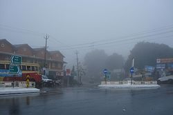
Kuttikkanam on a foggy day
|
|
| Coordinates: 9°34′42″N 76°58′22″E / 9.578301°N 76.9729°ECoordinates: 9°34′42″N 76°58′22″E / 9.578301°N 76.9729°E | |
| Country |
|
| State | Kerala |
| District | Idukki |
| Named for | Steep slopes, Valleys and hairpin roads |
| Government | |
| • Type | Panchayath |
| • Body | Peerumedu grama panchayath |
| Languages | |
| • Official | Malayalam, English |
| Time zone | IST (UTC+5:30) |
| Vehicle registration | KL-37 |
| Nearest city | Kanjirappally, Mundakayam |
Kuttikkanam (Malayalam: കുട്ടികാനം), is a hill station in Idukki district, Kerala, southern India. It is 3,500 feet (1,100 m) above sea level and surrounded by lush green tea plantations. It is within the territory of Peermade. Kanjirappally and Mundakkayam are the nearest towns.
In the 16th century the territory was under the rule of Changanacherry kings and was uninhabited. In 1756, the King of Travancore conquered Changanacherry, and brought the place under his supremacy. A Church Mission Society missionary, Henry Baker, started coffee plantations, and under the regency of Sri Moolam Thirunal these became tea plantations.
Under the British Raj in India, Kuttikkanam became an up-market resort. Since at first there was no road but only a pathway, the British started the Aerial Ropeway Ltd, Travancore state's first public limited company. The summer palace of the Travancore kings was located in Kuttikkanam.
During the British period and after, manpower was brought to Kuttikkanam from various parts of Kerala and Tamil Nadu. The descendants of these migrant workers constitute the major part of the population of Kuttikkanam.
...
Wikipedia
