Kuri Chhu
| Kuri Chhu | |
|---|---|
 |
|

Kuri Chhu (centre)
|
|
| Country | Bhutan |
| Basin features | |
| River system | Manas River, Brahmaputra River |
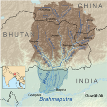
The Kuri Chhu, also known as the Lhozhag Xung Qu (tib. lho brag gzhung chu) or Norbu Lag Qu (tib. nor bu lag chu), is a major river of eastern Bhutan, that has formed a scenic valley with high peaks and steep hills. Kuri Chhu is a tributary of the Manas River system, which is the largest river of Bhutan and a major tributary of the Brahmaputra River that drains most of eastern Bhutan.
The Kuri Chhu originates from the Kula Kangri Glacier in the Tibet Autonomous Region of People's Republic of China where it is known as the Lhozhag Nub Qu (Tibetan: lho brag nub chu, Roman Dzongkha: Lhobrak Chhu) and Xung Qu (Tibetan: gzhung chu), and another origin is the Lhozhag Xar Qu (Tibetan: lho brag shar chu) a.k.a. Damxoi Xung Qu (tib. gtam zhol gzhung chu) originates between the Xoijin Qênri and the Tar Lhari. It crosses into Bhutan at a relatively low elevation of 1,200 metres (3,900 ft), flowing in a southerly direction up to Nye and changes its course to south-easterly until it reaches Lhuentse Dzong. Further downstream the Kuri Chhu flows in a south-westerly direction and joins the Manas River.
The main tributaries of the Kuri Chhu are the Tangkhar Chhu, the Chuneygang Chhu, the Kilung Chhu, the Rong Chhu, the Nye and the Dungkhar Chhu.
Geographically Bhutan forms a giant natural staircase. Starting from the plains of India, in the south, at an altitude of around 100 metres (330 ft), the elevation rises to the high Himalayan peaks of over 7,000 metres (23,000 ft), in the north, on the borders with Tibet. Eastern Bhutan lies across the Donga range running north-south across the country and is crossed by the 3,780-metre (12,400 ft) high Thrumshingla pass. From this high pass the terrain drops precipitously to the low valleys of the Kuri Chhu.
On a clear day, one can see Gangkhar Puensum, Bhutan’s highest peak, from Thrumshingla pass. After crossing the pass, for a drive to Sengor the road descends about 700 metres (2,300 ft) in 22 kilometres (14 mi). After Sengor the road begins its descent into the Kuri Chhu valley. Numerous waterfalls and streams slide down the sharp cliffs and leap onto the road. In some places the road is critically cut into the side of the vertical cliff. Finally the road leaves Thrumshingla National Park area and emerges into the upper part of the large valley of the Kuri Chhu, lush with bamboos and ferns. The area is also good for bird watching. The winding road gradually descends through corn fields, rice terraces and tropical fruit plants begin to appear. At Zuri Zampa (bridge) it gets to the lowest point at 570 metres (1,870 ft), after a marked descent of about 3,500 metres (11,500 ft) from Thrumshingla Pass
...
Wikipedia
