Kumbia, Queensland
|
Kumbia Queensland |
|||||||||||||
|---|---|---|---|---|---|---|---|---|---|---|---|---|---|

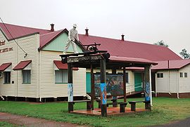
Kumbia Pioneer tribute beside the Memorial School of Arts hall
|
|||||||||||||
| Coordinates | 26°42′S 151°40′E / 26.700°S 151.667°ECoordinates: 26°42′S 151°40′E / 26.700°S 151.667°E | ||||||||||||
| Population | 352 (2011 census) | ||||||||||||
| Postcode(s) | 4610 | ||||||||||||
| Location | |||||||||||||
| LGA(s) | South Burnett Region | ||||||||||||
| State electorate(s) | Nanango | ||||||||||||
| Federal Division(s) | Maranoa | ||||||||||||
|
|||||||||||||
Kumbia is a small town and locality in the South Burnett Region, Queensland, Australia. The town is located on the Bunya Highway, 231 kilometres (144 mi) north west of the state capital, Brisbane. At the 2011 census, Kumbia had a population of 352 people.
Kumbia Post Office opened on 19 July 1915 (a receiving office had been open from 1913).
The Kumbia State School opened on 2 February 1914 and celebrated its 100-year anniversary in 2014.
As a memorial for World War I, a memorial school of arts hall was established in 1922.
Kumbia has many small street-front shops including a Fuel Station with post office, store and caravan park, a mechanic, a general store, a butcher's shop and a pub.
Vodafone will serve the town and surrounding area with mobile phone service as part of the National Blackspot Program from Q3 2016.
...
Wikipedia

