Kulim, Kedah
|
Kulim District كوليم கூலிம் |
||
|---|---|---|
 |
||
|
||
| Location of Kulim in Malaysia | ||
| Coordinates: 5°21′36″N 100°32′59″E / 5.36000°N 100.54972°ECoordinates: 5°21′36″N 100°32′59″E / 5.36000°N 100.54972°E | ||
| Country | Malaysia | |
| State | Kedah | |
| Establishment | mid-18th century | |
| Granted municipality status | 2001 | |
| Government | ||
| • Tuan Yang DiPertua MPKK | Tn. Abdul Aziz Bin Haji Abdul Ghani AMK, BCK | |
| Area | ||
| • Total | 764 km2 (295 sq mi) | |
| Population (2015) | ||
| • Total | 85,309 | |
| • Density | 590/km2 (1,500/sq mi) | |
| Time zone | MST (UTC+8) | |
| • Summer (DST) | Not observed (UTC) | |
| Postal code | 09000 | |
| International dialling code prefix | +6044 (landline only) | |
| Website | www |
|
The Kulim District is a district in the state of Kedah, Malaysia. It is located at the southeastern corner of Kedah, bordering the state of Penang to the west and a mere 27 km (17 mi) east of George Town, Penang's capital city. Due to its closer proximity to Penang, Kulim is also part of Greater Penang, Malaysia's second largest conurbation, with the town's logistical needs being met by Penang's well-developed transportation infrastructure.
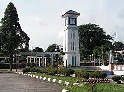
The Kulim’s independence clock was officiated by the Sultan of Kedah (15 September 1957) and serves as the unofficial landmark for the city of Kulim. The construction of the clock was completed within 3 months and upon completion, was made formalized by DYMM Tuanku Sultan Badlishah Ibni Almarhum Yang Di Pertuan Paduka Seri Sultan Abdul Hamid Shah, KOM, CMG, KBE Sultan Kedah on 15 September 1957, or 2 weeks after the declaration of independence of Malaysia (31 August 1957).
Kulim District is divided into 15 mukims, which are:
Kulim District is administered by Kulim Municipal Council.
...
Wikipedia


