Kudremukh National Park
| Kudremukha | |
|---|---|
| ಕುದುರೆಮುಖ | |

Kudremukha - The Horse Face
|
|
| Highest point | |
| Elevation | 1,894 m (6,214 ft) |
| Coordinates | 13°07′46.24″N 75°16′06.79″E / 13.1295111°N 75.2685528°ECoordinates: 13°07′46.24″N 75°16′06.79″E / 13.1295111°N 75.2685528°E |
| Naming | |
| Translation | ಕುದುರೆಮುಖ (Kannada) |
| Geography | |
| Location | Chikkamagaluru, Karnataka, India |
| Parent range | Western Ghats |
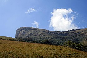
Kuduremukha is a mountain range and name of a peak located in Chikkamagaluru district, in Karnataka, India. It is also the name of a small hill station cum mining town situated near the mountain, about 48 kilometres from Karkala and around 20 kilometres from Kalasa. The name Kuduremukha literally means 'horse-face' (in the Kannada language) and refers to a particular picturesque view of a side of the mountain that resembles a horse's face. It was also referred to as 'Samseparvata', historically since it was approached from Samse village. Kuduremukh is Karnataka's 3rd highest peak after Mullayangiri and Baba Budangiri. The nearest airport is Mangalore International Airport at Mangalore which is at distance of 99 kilometres.
The Kudremukh National Park (latitude 13°01'00" to 13°29'17" N, longitude 75°00'55' to 75°25'00" E) is the second largest Wildlife Protected Area (600.32 km2) belonging to a tropical wet evergreen type of forest in the Western Ghats. Kudremukh National Park is located in Dakshina Kannada, Udupi District and Chikkamagaluru districts of the State of Karnataka. The Western Ghats is one of the thirty four hotspots identified for bio-diversity conservation in the world. Kudremukh National Park comes under the Global Tiger Conservation Priority-I, under the format developed jointly by the Wildlife Conservation Society (WCS) and World Wide Fund-USA.
The southern and western sides of the park form the steep slope of the Western Ghats ridge line, with the altitude varying from 100 m - 1892 m (peak). The northern, central and the eastern portions of the park constitute a chain of rolling hills with a mosaic of natural grassland and shola forests. Kudremukh receives an average annual rainfall of 7000 mm, largely due to the forest types of mainly evergreen vegetation that can be found here.
Well known environmentalist and tiger expert undertook a detailed and systematic survey of the distribution of the endangered lion-tailed macaque in Karnataka during 1983-84 with support from the Government of Karnataka. He observed that suitable and extensive rainforest habitat for the lion-tailed macaque existed in Kudremukh and that the tract probably harboured the largest contiguous population of lion-tailed macaques in the Western Ghats, outside the Malabar region. He further suggested that lion-tailed macaques could be effectively used as a 'flagship' species to conserve the entire biotic community in the region and prepared a conservation plan for the survival of wild populations of lion-tailed macaques in the region delineating the present national park area as a proposed nature reserve. Based on his report, the Karnataka State Wildlife Advisory Board suggested to the government that Kudremukh National Park be created. Subsequently, in 1987, the Government of Karnataka declared these reserved forests as a national park based on the above suggestion.
...
Wikipedia

