Krumovitsa
| Krumovitsa | |
|---|---|

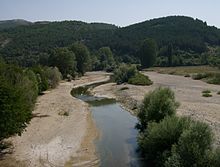
A view of the Krumovitsa
|
|
| Country | Bulgaria |
| Basin features | |
| Main source | Maglenik Ridge, Rhodope Mountains 930 m (3,050 ft) |
| River mouth |
Arda River 151 m (495 ft) |
| Basin size | 671 km2 (259 sq mi) |
| Physical characteristics | |
| Length | 58 km (36 mi) |
The Krumovitsa (Bulgarian: Крумовица) is a river in the eastern Rhodope Mountains of Bulgaria. The river valley is formed by the Krumovitsa River and the Djushun River together with the surrounding low mountain slopes.
The rivers flow through deep canyons and open valleys, with the vegetation along the riverbanks dominated by Alnus, Salix, Populus, Rubus, Rosa and Tamarix. Dry grassland, scrub and broadleaved forests cover the neighbouring hills. The forests are dominated by Quercus, Carpinus and Mediterranean tree species. Juniperus is predominant in the sclerophyllous scrub. Land-uses are extensive rearing of sheep and cattle, hunting and forestry, but the area is becoming progressively depopulated due to local emigration.
The area includes the valleys in the middle course of the Krumovitsa River and its tributary Djushun Dere with the adjacent hills and slopes of the Eastern Rhodopes. It covers the sections of the Krumovitsa between the village of Gorna Kula and the mouth of the Djushun Dere, from where it reaches the grounds of the village of Chal to the east. The Krumovitsa river valley in this region is between 300 and 1000 m wide, at places occupied entirely by the sandy riverbed itself. There are differently expressed belts of riverine tree vegetation mainly of poplars (Populus spp.), willows (Salix spp.), black alder (Alnus glutinosa), etc. It is mixed with shrub vegetation of blackberry (Rubus spp.), dog rose, etc. At many places shrubs, mainly of Tamarix spp., and grasses grow in the riverbed itself.
The Krumovitsa banks are often steep, covered with low rocks. Its valley is occupied by farmland patches. The Djushun Dere river valley is mostly narrow and cuts deeply in volcanic rocks with very steep cliffs along the riverbed, waterfalls and small caves. The vegetation along its banks is scarce and dominated by shrub species. Both rivers have a strongly fluctuating water level – very high in February–March and almost none in July–August (except in isolated pools). Most of the area includes low-mountain ridges and slopes. Its bigger part is treeless but the most south-eastern regions are covered by old broadleaved forest of Quercus frainetto, Quercus dalechampii, at places mixed with Carpinus orientalis. Secondary forests have replaced the old ones that have been cut in the recent decades. Typical for the slopes and ridges of the two valleys are the numerous rocks, rock complexes and crests, along with the extensive areas covered by shrub formations of Mediterranean type, dominated by Juniperus oxycedrus, etc. There are many stony sections, overgrown with grass vegetation.
...
Wikipedia
