Kreimbach-Kaulbach
| Kreimbach-Kaulbach | ||
|---|---|---|
|
||
| Coordinates: 49°33′06″N 7°37′50″E / 49.55167°N 7.63056°ECoordinates: 49°33′06″N 7°37′50″E / 49.55167°N 7.63056°E | ||
| Country | Germany | |
| State | Rhineland-Palatinate | |
| District | Kusel | |
| Municipal assoc. | Lauterecken-Wolfstein | |
| Government | ||
| • Mayor | Wolfgang Caspers | |
| Area | ||
| • Total | 9.05 km2 (3.49 sq mi) | |
| Elevation | 220 m (720 ft) | |
| Population (2015-12-31) | ||
| • Total | 758 | |
| • Density | 84/km2 (220/sq mi) | |
| Time zone | CET/CEST (UTC+1/+2) | |
| Postal codes | 67757 | |
| Dialling codes | 06308 | |
| Vehicle registration | KUS | |
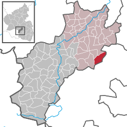
Kreimbach-Kaulbach is an Ortsgemeinde – a municipality belonging to a Verbandsgemeinde, a kind of collective municipality – in the Kusel district in Rhineland-Palatinate, Germany. It belongs to the Verbandsgemeinde Lauterecken-Wolfstein.
The municipality lies on the river Lauter (also called the Waldlauter, to distinguish it from other rivers in German-speaking Europe named ), southeast of the Königsberg in the North Palatine Uplands. Kreimbach lies on the river’s right bank at an elevation of some 198 m above sea level near where the namesake brook, the Kreimbach, flowing by from the northeast, empties into the Lauter. The flat lands before the slopes leading up the Kreimberg (390 m) and the Kreimbacher Kalmit (408 m) together with the Leisberghügel (hill) are broader than the Kaulbach floodplain on the left bank because the lower end of the Kreimbach cuts through them, coming from the east. The Kreimberg is “torn up” on its south side by a great hard-stone quarry covering some 44.4 ha. On the heights above the Kaulbach railway station, which has been out of service since late 2000, once lay within Kreimbach’s limits a smaller quarry, one that yielded sandstone, but this was given up even before the First World War. Another, bigger one was to be found on the Winterbach, which was shut down in the 1980s. It was from this pit that the stone for both the local churches was drawn, as well as for the old Kaulbach schoolhouse and, at least for a considerable amount of the work, for the reconstruction of Alexander’s Church (Alexanderskirche) in Zweibrücken after the Second World War. Both Kreimbach’s and Kaulbach’s southern limits touch Kaiserslautern. Above the quarries north of the Kreimbach, spreading across a high plateau, is the Heidenburg (“ Castle”), a prehistoric refuge castle or fortified living area where a tall lookout tower also stands. Kaulbach lies on the lower reaches of its own namesake brook, the Kaulbach, on the Waldlauter’s left bank. The Waldlauter thus runs between both the main centres, flowing in a great bow as it passes. Kaulbach arose on a rather small floodplain between the mouth of the Kaulbach and the bank of the Lauter. The geological setting points to long forsaken quarries, a sandstone quarry south of the Kaulbach and to the west a melaphyre quarry. The sedimentary rock was used mainly for building houses, while the volcanic rock was mainly used for building roads and railways. The municipal area measures 904 ha, of which 434 ha is cropland and meadows, 5 ha is open water and 355 ha is wooded. Of the total, 372 ha is Kreimbach’s.
...
Wikipedia


