Krødsherad
| Krødsherad kommune | |||
|---|---|---|---|
| Municipality | |||
 |
|||
|
|||
 Krødsherad within Buskerud |
|||
| Coordinates: 60°11′42″N 9°39′52″E / 60.19500°N 9.66444°ECoordinates: 60°11′42″N 9°39′52″E / 60.19500°N 9.66444°E | |||
| Country | Norway | ||
| County | Buskerud | ||
| District | Ringerike | ||
| Administrative centre | Noresund | ||
| Government | |||
| • Mayor (2003) | Olav Skinnes (Tverrpolitisk bygdeliste) | ||
| Area | |||
| • Total | 375 km2 (145 sq mi) | ||
| • Land | 340 km2 (130 sq mi) | ||
| Area rank | 248 in Norway | ||
| Population (2004) | |||
| • Total | 2,201 | ||
| • Rank | 327 in Norway | ||
| • Density | 6/km2 (20/sq mi) | ||
| • Change (10 years) | -4.6 % | ||
| Demonym(s) | Krylling | ||
| Time zone | CET (UTC+1) | ||
| • Summer (DST) | CEST (UTC+2) | ||
| ISO 3166 code | NO-0622 | ||
| Official language form | Neutral | ||
| Website | www |
||
|
|
|||
Krødsherad (Krødsherad kommune) is a municipality in Buskerud county, Norway. The administrative centre of the municipality is the village of Noresund. The municipality of Krødsherad was established when it was separated from the municipality of Sigdal on 1 January 1901.
The Old Norse form of the name was Krœðisherað. The first element is the genitive case of the name of the lake Krøderen, the last element is herað meaning "district". Prior to 1918, the name was spelled Krødsherred.
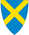
The coat-of-arms is from modern times. They were granted on 11 September 1981. The arms are supposedly canting arms. In older times, the name, Krødsherad, was commonly misunderstood as the word kross meaning "cross" or the area where two valleys crossed. Thus the saltire cross was taken as a symbol in the arms. New insights, however, derive the name from Krøderen, or a lake with a sharp curve (hooked-lake).
The district lies on the Krøderfjord in Hallingdal, and borders on the municipalities of Ringerike, Flå, Sigdal and Modum. The municipality lies only 10 old Norwegian miles from Oslo. Settlement is scattered, with some concentration around the municipality's two principal centers, Noresund situated on the east side of Lake Krøderen and Krøderen at the southern end of Lake Krøderen.
Agriculture is the primary industry with most agricultural land arable and mostly used for grain cultivation. The forestry industry also has historically been important. With the shoreline at Krøderen and the high mountains at Norefjell, the municipality enjoys a spectrum of natural environments from lake to mountain. As a result, there are many vacation homes in the municipality and tourism, especially winter sports in the Norefjell area, is an important contribution element in the economy.
...
Wikipedia


