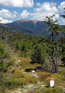
Králický Sněžník
| Králický Sněžník | |
|---|---|
| Śnieżnik Kłodzki | |

Southern view of the mountain
|
|
| Highest point | |
| Elevation | 1,424 m (4,672 ft) |
| Coordinates | 50°12′25″N 16°50′56″E / 50.20694°N 16.84889°ECoordinates: 50°12′25″N 16°50′56″E / 50.20694°N 16.84889°E |
| Geography | |
| Location | Czech Republic—Poland border |
| Parent range | Śnieżnik Mountains |
| Topo map |  |
Králický Sněžník (Czech: [ˈkraːlɪtskiː ˈsɲɛʒɲiːk]) or Śnieżnik Kłodzki (Polish: [ˈɕɲeʐɲik]) is a mountain in the Eastern Bohemia, located on the border between the Czech Republic and Poland. The name Sněžník or Śnieżnik derives from the word for "snow"; the mountain has snow cover for up to eight months a year. In Czech the adjective Králický (from the nearby town of Králíky) is added to distinguish it from the mountain called Děčínský Sněžník (near the town of Děčín). An alternative Polish name is Śnieżnik Kłodzki, from the town of Kłodzko. In German the mountain is known as Glatzer Schneeberg (from Glatz, the German name for Kłodzko), Grulicher Schneeberg (from Gruhlich, the German name for Králíky), or Spieglitzer Schneeberg (from Spieglitz, which is now part of Staré Město).
The mountain is the highest peak of the Śnieżnik massif (called Králický Sněžník in Czech, Masyw Śnieżnika in Polish, Glatzer Schneegebirge in German). It lies between the town Králíky and the Kłodzko Gap that separates it from the Golden Mountains.
The massive was formed during the Tertiary. Sněžník lies on the water divide for the Black Sea (the Morava) and the Baltic Sea (the Nysa Kłodzka). Klepáč, the water divide for the Black Sea, the Baltic Sea, and the North Sea (the Lipkovský Stream) lies 7 km (4 mi) south of Sněžník.
...
Wikipedia

