Kottapadi
| Kottapadi | |
|---|---|
| village | |
 |
|
| Coordinates: 10°36′54″N 76°1′43″E / 10.61500°N 76.02861°ECoordinates: 10°36′54″N 76°1′43″E / 10.61500°N 76.02861°E | |
| Country |
|
| State | Kerala |
| District | Thrissur |
| Government | |
| • Body | Guruvayur Municipality |
| Languages | |
| • Official | Malayalam, English |
| Time zone | IST (UTC+5:30) |
| PIN | 680505 |
| Telephone code | 91487 |
| Vehicle registration | KL-08/KL-46 |
| Nearest city | Trichur |
| Lok Sabha constituency | Trichur |
| Civic agency | Guruvayur Municipality |
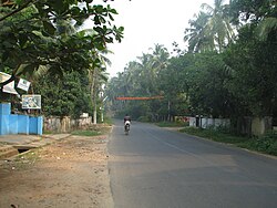
Kottapadi is a gateway of Guruvayur town in the district of Thrissur, Kerala, South India. Kottapadi literally translates to Gates to Fort. The fort here refers to the Punnathur Kotta. Kottapadi has now gained prominence for this fort, which in now used to house elephants belonging to the Guruvayoor temple. (Anakkotta in Malayalam, literally translated as "Elephant Fort") Elephants that are an integral part of certain temple rituals are trained here.
Kottapadi being a coastal village (6 km from sea) like many other parts of Kerala has white sand and earlier growing coconuts was a major industry, Now due to rapid urbanisation, most of this village has become a small town. Kottapadi is located only 2 kilometers away from Guruvayur temple. Many tourists come here for visiting the Punnathur Kotta. There are more than 60 elephants here. These elephants belong to the Guruvayur Temple, where prominent devotees offer it to Lord Guruvayurappan. Earlier this place was the palace (Punnathur Kotta or Punathur Fort) of a local ruler. Prominent Shiva temple at Mammiyur is located close by.
Nearest Airport: Kochi
Nearest Railway Station: Guruvayur, Trichur
Nearest Major Towns: Guruvayur, Chavakkad, Kunnamkulam
Little Flower women's college, Aryabhatta women's college, Mercy college.
St Lazer's church, St George orthodox church.
Chembalakulangara Bhagavathi kshethram, Sree Subramanya Kshethram, Kaveed Karthyani Kshetram.
...
Wikipedia
