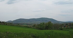
Kosmaj
| Kosmaj | |
|---|---|

Panoramic view on Kosmaj
|
|
| Highest point | |
| Elevation | 626 m (2,054 ft) |
| Coordinates | 44°27′56″N 20°33′56″E / 44.46556°N 20.56556°ECoordinates: 44°27′56″N 20°33′56″E / 44.46556°N 20.56556°E |
| Geography | |
Kosmaj (Serbian Cyrillic: Космај, pronounced [kɔ̌smaːj]) is a mountain south of Belgrade, the capital of Serbia. With an elevation of 626 meters, it is the highest point of the entire Belgrade City area and is nicknamed one of two "Belgrade mountains" (the other being the mountain of Avala).
The Kosmaj, is located 40 kilometers south-east of Belgrade. Entire area of the mountain belongs to the Belgrade City area, majority of it being in the municipalities of Mladenovac and Sopot, with eastern slopes being in the municipality of Grocka, and northern and north-western extensions in the municipalities of Barajevo and Voždovac.
It is speculated that the mountain was named after the Celtic word cos meaning woods, and maj pre-Indo-European word meaning mountain. Alternative explanations suggest the connection to the ancient mountain-dwelling Slavic pagan deity Kozmaj/Kasmaj, the protector of woods, animals and the cosmos. The mountain has never been known under any other name, until it was forcefully molded by the Romans into "Casa Maias", house of Maia, in order to promote worship of their goddess of spring among the locals.
The mountain is 5.5 kilometers long and built of flysch, serpentine, and magmatic rocks. The highest peak is also named Kosmaj. It is a low, island mountain, the second northernmost in Šumadija region (after Avala). Until 600,000 years ago, when the surrounding low areas were flooded by the inner Pannonian Sea, the Kosmaj was an island, just as the neighboring mountains (Avala, Fruška Gora to the north, etc.), thus earning its geographical classification. The Kosmaj remains an island mountain as the plateaux around it are low and mostly flat. In the north it extends into the direction of Trešnja, the southernmost extension of the Avala, while in the north-west it extends into Parcanski vis ("Parcani rising"), 408 meters high ending section of the Kosmaj, which extends into the woods of Lipovička šuma.
...
Wikipedia

