Koromačno
|
Koromačno Valmazzinghi |
|
|---|---|
| Hamlet/Port | |

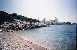
Overlooking the cement factory and port Koromačno from Pripogni beach
|
|
| Location Koromačno in Istria within Croatia | |
| Coordinates: 44°58′7″N 14°7′24″E / 44.96861°N 14.12333°ECoordinates: 44°58′7″N 14°7′24″E / 44.96861°N 14.12333°E | |
| Country | Croatia |
| Counties of Croatia | Istria |
| Municipality | Rasa, Istria County |
| Elevation | 0 m (0 ft) |
| Population (2011) | |
| • Total | 180 |
| Time zone | CET |
| Postal code | 52222 |
| Area code(s) | 3855 |
| Website | jadroagent |
Koromačno Croatian: Koromačno, Italian: Valmazzinghi as it was called under the Italian control). This is a small Hamlet adjacent to the Cement factory for which it was built in the early 1900 for the workers. It is also a small port to accept small cargo ships to carry the cement to other placed to be processed. It is located in the southernmost tip of the Croatian: Labinština, Italian: L'Albonese peninsula in Istria County in Croatia. It is nestled between Croatian: Crna Punta and Croatian: Ubac on the Gulf of Quarnero in the Adriatic Sea. It is one of the newest hamlet not even 100 years old. It is located about 15 km from Croatian: Labin / Italian: Albona, 1 km from Croatian: Brovinje, 3 km from Croatian: Skitača.
Koromačno, was named after a local wild plant, Croatian: koromač, Italian: finocchio or fennel, which grows wild all along the coastal area. In the 1800 the Austria-Hungary government started surveying Cadastral surveying mapping all the land in their possession. They made Cadastral maps, which show boundaries and ownership of property. A Cadastre is a register of real estate. In the English: District of Labin /Italian: Distretto di Albona this, as yet, unsettled was called Punta Cromatz.
...
Wikipedia

