Korbach
| Korbach | ||
|---|---|---|

Saint Nicholas Church
|
||
|
||
|
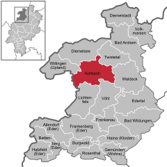
Location of Korbach within Waldeck-Frankenberg district
|
||
| Coordinates: 51°17′N 8°52′E / 51.283°N 8.867°ECoordinates: 51°17′N 8°52′E / 51.283°N 8.867°E | ||
| Country | Germany | |
| State | Hesse | |
| Admin. region | Kassel | |
| District | Waldeck-Frankenberg | |
| Government | ||
| • Mayor | Klaus Friedrich | |
| Area | ||
| • Total | 123.98 km2 (47.87 sq mi) | |
| Elevation | 384 m (1,260 ft) | |
| Population (2015-12-31) | ||
| • Total | 23,515 | |
| • Density | 190/km2 (490/sq mi) | |
| Time zone | CET/CEST (UTC+1/+2) | |
| Postal codes | 34497 | |
| Dialling codes | 05631 | |
| Vehicle registration | KB | |
| Website | Stadt Korbach | |
Korbach (pronunciation: ˈkoːɐˌbax) is the district seat of Waldeck-Frankenberg in northern Hesse, Germany. It is over a thousand years old and a former Hanseatic town. It is located on the German Timber-Frame Road. In 2018, the town will host the 58th Hessentag state festival.
Korbach lies at the northeast edge of the Rhenish Slate Mountains (here known as the Waldeck'sches Upland, the second word being a German proper name, not the English word "upland"). Neighbouring towns and communities are, clockwise from the northwest, Willingen, Diemelsee, Twistetal, Waldeck, Vöhl, Lichtenfels (likewise all in Waldeck-Frankenberg) and Medebach (Hochsauerlandkreis in North Rhine-Westphalia).
The town lies on an unwooded tableland called the Waldecker Tafel that once harboured a great many wild chickens, leading to the townsfolk's nickname as "Feldhühnerchen" ( ≈ "little field chickens"). Not only the main town, but also outlying centres such as Lelbach (615 inhabitants), Lengefeld (512 inhabitants), Nordenbeck (195 inhabitants), Ober-Ense (228 inhabitants) and Nieder-Ense (272 inhabitants) lie on the Waldecker Tafel or at its edge. In the eastern part of the municipal area, where the outlying centres of Helmscheid (202 inhabitants), Strothe (250 inhabitants) and Meineringhausen (947 inhabitants) lie, begins the North Hesse Hills (nordhessisches Hügelland), which stretch from the Rhenish Slate Mountains to the Habichtswald range west of Kassel. In the west lie the constituent communities of Alleringhausen (91 inhabitants), Eppe (686 inhabitants), Nieder-Schleidern (193 inhabitants) and Hillershausen (334 inhabitants) in the foothills of the Sauerland. The highest peaks in the Korbach municipal area are the Widdehagen (635 m) near Rhena (584 inhabitants) and the Eisenberg (562 m), which despite its name – meaning "Iron Mountain" – is well known for gold-bearing ore found there. Perhaps more fittingly, the outlying community lying on the Eisenberg is called Goldhausen (329 inhabitants).
...
Wikipedia


