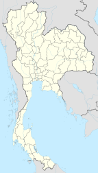
Korat, Thailand
|
Nakhon Ratchasima นครราชสีมา |
|
|---|---|
| City Municipality | |

Nakhon Ratchasima
|
|
| Nickname(s): Khorat | |
 Nakhon Ratchasima Province |
|
| Nakhon Ratchasima Province | |
| Coordinates: 14°58′50″N 102°6′00″E / 14.98056°N 102.10000°E | |
| Country | Thailand |
| District | Mueang Nakhon Ratchasima |
| Province | Nakhon Ratchasima |
| - Settled | 1656 (Ayutthaya Period) |
| - as Sanitary districts | 3 Jan 1908 |
| - as Municipality | 7 Dec 1935 |
| Government | |
| • Type | City Municipality |
| • Mayor | Surawuth Cherdchai |
| • Municipal Clerk | Arlom Tangtaku |
| Area | |
| • City Municipality | 37.5 km2 (14.5 sq mi) |
| • Land | 37.4 km2 (14.45 sq mi) |
| • Metro | 767.98 km2 (296.52 sq mi) |
| Population (2011) | |
| • City Municipality | 166,217 |
| • Density | 4,432.45/km2 (11,480.0/sq mi) |
| • Metro | 444,023 |
| • Metro density | 578.17/km2 (1,497.5/sq mi) |
| • Demonym | Korat |
| Time zone | ICT (UTC+7) |
| Area code(s) | 044 |
Nakhon Ratchasima (Thai: นครราชสีมา, pronounced [náʔkʰɔːn râːt.tɕʰa.sǐː.maː]) is one of the four major cities of Isan, Thailand, known as the "big four of Isan". The city is commonly known as Khorat (โคราช), a shortened form of its name. It is the governmental seat of the Nakhon Ratchasima Province and Nakhon Ratchasima District. Nakhon Ratchasima is the heart of the Nakhon Ratchasima metropolitan area.
Khorat is at the western edge of the Khorat Plateau. Historically, it once marked the boundary between Lao and Siamese territory. It is the gateway to the Lao-speaking northeast (Isan). Its location is 14°58.5′N 102°6′E / 14.9750°N 102.100°ECoordinates: 14°58.5′N 102°6′E / 14.9750°N 102.100°E. As of 2010[update], the municipal area had a population of 142,645.
...
Wikipedia

