Konotop
|
Konotop Конотоп |
|||
|---|---|---|---|
| City | |||
 |
|||
|
|||
 |
|||
| Coordinates: 51°13′N 33°12′E / 51.217°N 33.200°E | |||
| Country | Ukraine | ||
| Oblast | Sumy | ||
| Founded | 1635 | ||
| Area | |||
| • Total | 43.78 km2 (16.90 sq mi) | ||
| Elevation | 171 m (561 ft) | ||
| Population (December 1, 2013) | |||
| • Total | 92,687 | ||
| Website | http://www.konotop-rada.gov.ua/ | ||
Coordinates: 51°13′N 33°12′E / 51.217°N 33.200°E
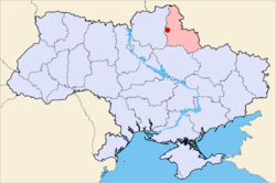
Konotop (Ukrainian: Конотоп, Ukrainian pronunciation: [konoˈtɔp]) is a city in northern Ukraine within the Sumy Oblast. Konotop is the center of the Konotop Raion (district), and is located about 129 km from Sumy, the Oblast capital. It is host to Konotop air base.
During the beginning of the 17th Century, Ukrainian Cossacks were first based in that area. The settlement was first mentioned in 1635 in various documents as Novoselitsa. In 1642 a Polish fortress was built in that place named after the river Konotopka. Probably the river disappeared, and another one was created, Yezuch. The fortification became a key point in the struggle against the Moscow state. Some historians suppose that Konotop was inhabited even before the Tatar-Mongolian invasion.
In 1659 the Battle of Konotop took place near the city, in which Ukrainian Cossacks led by Ivan Vyhovsky (allied with Poles and Crimean Tatars) defeated Muscovite forces. In 1782 Konotop was granted municipal rights.
...
Wikipedia


