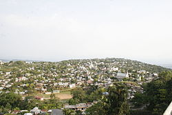
Kolasib
| Kolasib | |
|---|---|
| Town | |

kolasib, mizoram
|
|
| Coordinates: 24°13′52″N 92°40′34″E / 24.23111°N 92.67611°ECoordinates: 24°13′52″N 92°40′34″E / 24.23111°N 92.67611°E | |
| Country | India |
| State | Mizoram |
| District | Kolasib |
| Government | |
| • Body | District Collector : Dr Arun T |
| Elevation | 888 m (2,913 ft) |
| Population (2001) | |
| • Total | 18,852 |
| Languages | |
| • Official | Mizo |
| Time zone | IST (UTC+5:30) |
| Vehicle registration | MZ |
| Website | mizoram |
Kolasib is a district as well as a district headquarters of Kolasib district in Mizoram, India.
As of 2011[update] India census, Kolasib had a population of 83,955. Males constitute 51.12% of the population and females 48.88%. Kolasib has an average literacy rate of 93.50%, higher than the national average of 74.04%: male literacy is 94.57%, and female literacy is 92.38%. Population growth rate of Kolasib district was 27.28 percent during the decade.
Kolasib is agriculture-dominated economy with a few service sector jobs as it is a district capital. A large number of people cultivate beetle nut, oil palms, rice, wheat and fish which is both consumed and exported to other districts of Mizoram.
A helicopter service by Pawan Hans has been started which connects the Aizawl with Kolasib. The distance between Kolasib and Aizawl through NH 54 is 83 km and is connected with regular service of bus and Maxi-Cabs.
There is one college - Government Kolasib College, under Mizoram University and a number of public and private schools.
The Major Higher Secondary School in Kolasib are:
The Major Newspapers in Kolasib are:
Major Television Cable Network in Kolasib are:
...
Wikipedia


