Kolar
|
Kolar ಕೋಲಾರ |
|
|---|---|
| city municipal corporation | |

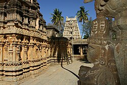
Someshwara Temple, 14th century Vijayanagara style
|
|
| Location in Karnataka, India | |
| Coordinates: 13°08′00″N 78°08′00″E / 13.1333°N 78.1333°ECoordinates: 13°08′00″N 78°08′00″E / 13.1333°N 78.1333°E | |
| Country |
|
| State | Karnataka |
| District | Kolar |
| Named for | Sericulture,Horticulture,Milk Production, |
| Area | |
| • Total | 46.56 km2 (17.98 sq mi) |
| Elevation | 821 m (2,694 ft) |
| Population (2011) | |
| • Total | 183,462 |
| • Density | 3,900/km2 (10,000/sq mi) |
| Languages | |
| • Official | Kannada |
| Time zone | IST (UTC+5:30) |
| PIN | 563101, 563102, 563103 |
| Telephone code | 08152 |
| Vehicle registration | KA-07 |
| Website | www |
Kolar ![]() pronunciation is a city in the Indian state of Karnataka. It is the headquarters of Kolar District and is known for gold mining. Kolar is popularly known as the land of silk, milk, and gold. The town is famous for the Someshwara temple and the Kolaramma temple. Kolaramma is considered as Grama devathe for Kolar.
pronunciation is a city in the Indian state of Karnataka. It is the headquarters of Kolar District and is known for gold mining. Kolar is popularly known as the land of silk, milk, and gold. The town is famous for the Someshwara temple and the Kolaramma temple. Kolaramma is considered as Grama devathe for Kolar.
Kolar is located at 13°08′N 78°08′E / 13.13°N 78.13°E. with an average elevation of 822 metres (2,697 ft).
It is located at a distance of about 70 kilometres (43 mi) from Bengaluru and 50 km from Bangalore International Airport 32 kilometres (20 mi) from Kolar Gold Fields. The city is located on the southern maidan (plains) region of Karnataka. The Ammerallikere, a tank, forms its eastern boundary. To the north is the Kodikannur tank, the main source of water supply to the city. The nearest railway junction is Kolar. Kolar is having good road transportation than, Rail amenities. It is situated on the Bengaluru - Chennai National Highway-75.
...
Wikipedia

