Koga, Ibaraki
|
Koga 古河市 |
|||
|---|---|---|---|
| City | |||

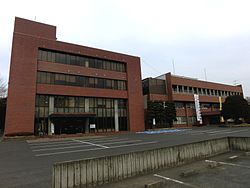
Koga city hall
|
|||
|
|||
 Location of Koga in Ibaraki Prefecture |
|||
| Coordinates: 36°10′41.7″N 139°45′19.6″E / 36.178250°N 139.755444°ECoordinates: 36°10′41.7″N 139°45′19.6″E / 36.178250°N 139.755444°E | |||
| Country | Japan | ||
| Region | Kantō | ||
| Prefecture | Ibaraki Prefecture | ||
| Government | |||
| • Mayor | Kenichiro Sugaya (since December 2012) | ||
| Area | |||
| • Total | 123.58 km2 (47.71 sq mi) | ||
| Population (September 2015) | |||
| • Total | 140,770 | ||
| • Density | 1,140/km2 (3,000/sq mi) | ||
| Time zone | Japan Standard Time (UTC+9) | ||
| - Tree | Zelkova serrata | ||
| - Flower | Prunus persica | ||
| Phone number | 0280-92-3111 | ||
| Address | 2248 Shimoōno, Koga-shi, Ibaraki-ken 306-0291 | ||
| Website | Official website | ||
Koga (古河市 Koga-shi?) is a city located in Ibaraki Prefecture, in the northern Kantō region of Japan. As of September 2015, the city had an estimated population of 140,770 and a population density of 1140 persons per km². Its total area was 123.58 square kilometres (47.71 sq mi).
Koga is located in the extreme southwestern corner of Ibaraki Prefecture
Koga developed in the Muromachi period as the Koga kubō, a secondary government created by the Ashikaga shogunate to rule eastern Japan. However, the site has been inhabited since the Jōmon period and was one of the largest centers for iron production in eastern Japan in the Heian period. In the Sengoku period, it developed into a castle town and became the seat of the daimyō of Koga Domain under the Edo period Tokugawa shogunate. The town of Koga was established on April 1, 1889 with the creation of the municipalities system. The modern city was founded on August 1, 1950. On September 12, 2005, Koga absorbed the towns of Sanwa and Sōwa (both from Sashima District) to create the new and expanded city of Koga. The new city hall is now located at the former town of Sōwa.
...
Wikipedia


