Koerich
|
Koerich Käerch |
||
|---|---|---|
| Commune | ||

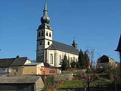
Koerich church
|
||
|
||
 Map of Luxembourg with Koerich highlighted in orange, and the canton in dark red |
||
| Coordinates: 49°40′00″N 5°57′00″E / 49.6667°N 5.95°ECoordinates: 49°40′00″N 5°57′00″E / 49.6667°N 5.95°E | ||
| Country |
|
|
| Canton | Capellen | |
| Government | ||
| • Mayor | Pia Flammang-Risch | |
| Area | ||
| • Total | 18.88 km2 (7.29 sq mi) | |
| Area rank | 61st of 105 | |
| Highest elevation | 368 m (1,207 ft) | |
| • Rank | 77th of 105 | |
| Lowest elevation | 262 m (860 ft) | |
| • Rank | 68th of 105 | |
| Population (2014) | ||
| • Total | 2,365 | |
| • Rank | 57th of 105 | |
| • Density | 130/km2 (320/sq mi) | |
| • Density rank | 54th of 105 | |
| Time zone | CET (UTC+1) | |
| • Summer (DST) | CEST (UTC+2) | |
| LAU 2 | LU00009007 | |
| Website | koerich.lu | |
Koerich (Luxembourgish: Käerch) is a commune and village in western Luxembourg. It is part of the canton of Capellen, which is part of the district of Luxembourg.
As of 2009[update], the commune of Koerich has a population of 2,310. The other small communities in the commune are Goeblange, Goetzingen and Windhof. With its onion-towered church standing above the ruins of the medieval castle, Koerich has a particularly attractive rural setting although it is only 15 km west of Luxembourg City.
The village lies in the valley of the Goeblange stream which flows down to the River Eisch to the west. It is at the junction of the CR 109 to Goeblange and Capellen and the CR 110 to Windhof and Dippach. The centre of the village is 295 m above sea level while the residential developments to the north and south rise to a height of 320 m. The streets in the village are therefore very hilly. The surrounding countryside is a mixture of forests and open fields with mixed farming.
The commune has a history extending back some 2,000 years. There is strong evidence that the Romans inhabited the area between the 1st and 4th centuries. To the south at Windhof the commune borders on the Kiem or Roman road from Trier to Reims and to the north-west, in the Miecher forest near Goeblange, impressive remains of a Roman farming community have been found. Two large villas have been excavated and the foundations partially rebuilt. There are other buildings and fortifications on the site which are now being uncovered.
...
Wikipedia

