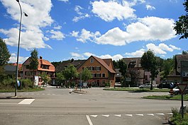
Koblenz (Switzerland)
| Koblenz | ||
|---|---|---|
 |
||
|
||
| Coordinates: 47°37′N 8°14′E / 47.617°N 8.233°ECoordinates: 47°37′N 8°14′E / 47.617°N 8.233°E | ||
| Country | Switzerland | |
| Canton | Aargau | |
| District | Zurzach | |
| Area | ||
| • Total | 4.08 km2 (1.58 sq mi) | |
| Elevation | 319 m (1,047 ft) | |
| Population (Dec 2016) | ||
| • Total | 1,632 | |
| • Density | 400/km2 (1,000/sq mi) | |
| Postal code | 5322 | |
| SFOS number | 4310 | |
| Surrounded by | Klingnau, Küssaberg (DE-BW), Leuggern, Rietheim, Waldshut-Tiengen (DE-BW) | |
| Website |
www SFSO statistics |
|
Koblenz (or Coblenz) is a town and municipality in the district of Zurzach in the canton of Aargau in Switzerland.
Koblenz is first mentioned in 10th or 11th Century as Confluentia, for the confluence of the Aare and Rhine rivers. In 1265 it was mentioned as Cobilz. In the Roman era a goods yard and watchtowers existed along the Rhine at this place. The remaining late Roman watchtower is listed as a heritage site of national significance. The town has been settled since the Middle Ages. The Koblenz boatmen had a monopoly over transport of goods from the then important market town of Zurzach downstream along dangerous currents of the Rhine towards Basel. With the arrival of the railway in the 19th century Koblenz and Zurzach lost this important source of income.
Koblenz has an area, as of 2009[update], of 4.08 square kilometers (1.58 sq mi). Of this area, 1.69 km2 (0.65 sq mi) or 41.4% is used for agricultural purposes, while 1.19 km2 (0.46 sq mi) or 29.2% is forested. Of the rest of the land, 0.8 km2 (0.31 sq mi) or 19.6% is settled (buildings or roads), 0.36 km2 (0.14 sq mi) or 8.8% is either rivers or lakes and 0.02 km2 (4.9 acres) or 0.5% is unproductive land.
Of the built up area, industrial buildings made up 1.7% of the total area while housing and buildings made up 9.1% and transportation infrastructure made up 7.8%. Out of the forested land, 26.0% of the total land area is heavily forested and 3.2% is covered with orchards or small clusters of trees. Of the agricultural land, 35.5% is used for growing crops and 5.6% is pastures. All the water in the municipality is flowing water. Of the unproductive areas, and .
...
Wikipedia


