Koći
| Koći | |
|---|---|

Panorama of Koći
|
|
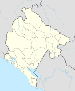
| Location of Koći in Montenegro | |
| Coordinates: 42°27′38″N 19°24′13″E / 42.46056°N 19.40361°ECoordinates: 42°27′38″N 19°24′13″E / 42.46056°N 19.40361°E | |
| Country |
|
| Municipality | Podgorica Municipality |
| Population (2011) | |
| • Total | 54 |
| Time zone | CET (UTC+1) |
| • Summer (DST) | CEST (UTC+2) |
| Area code | +382 20 |
| Car plates | PG |
Koći (Montenegrin and Serbian Cyrillic: Коћи, Albanian: Kojë) is a settlement in Podgorica Municipality, Montenegro, near the border with Albania. The village is inhabited by ethnic Albanians of the Roman Catholic faith.
Koći lies east of the capital Podgorica, north of Ubli. Koći is a village in the southeastern part of Kuči, called Kučka Krajina ("Kuči frontier") in eastern Montenegro, bordering Albania (see this geo-morphological map, legend B30). Kučka Krajina also compose Orahovo, Zatrijebač and Fundina. Kuči is one of the seven highlander tribes that constituted Brda ("the Hills") in the Principality of Montenegro.
Along with Albanian-inhabited Hoti and Gruda, Koći is, from Albanian point of view, part of the wider Malësia-region (Malesija).
In the mid-15th century Kuči is mentioned as a Serbian Orthodox tribe. When the Ottoman Empire occupied the Kuči area, the 1484 Ottoman defter (tax registry) registered 208 households in 11 villages. In the next one, 1497, it had had 338 households in 9 katuni (Pavlovići, Petrovići, Lješovići, Bitidosi, Lopari, Bankeći, Banjovići, Lazorce and Koći) and 2 villages.
...
Wikipedia

