Knox County, Missouri
| Knox County, Missouri | |
|---|---|

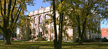
Knox County Courthouse in Edina
|
|
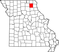
 Location in the U.S. state of Missouri |
|
 Missouri's location in the U.S. |
|
| Founded | February 14, 1845 |
| Named for | Henry Knox |
| Seat | Edina |
| Largest city | Edina |
| Area | |
| • Total | 507 sq mi (1,313 km2) |
| • Land | 504 sq mi (1,305 km2) |
| • Water | 2.8 sq mi (7 km2), 0.6% |
| Population (est.) | |
| • (2015) | 3,910 |
| • Density | 8.2/sq mi (3/km²) |
| Congressional district | 6th |
| Time zone | Central: UTC-6/-5 |
| Website | www |
| Knox County, Missouri | ||||
|---|---|---|---|---|
| Elected countywide officials | ||||
| Assessor | Anita James | Republican | ||
| Circuit Clerk | James Gibbons | Democratic | ||
| County Clerk | Marlene Spory | Republican | ||
| Collector | Brent Karhoff | Republican | ||
|
Commissioner (Presiding) |
Evan Glasgow | Republican | ||
|
Commissioner (District 1) |
Terry (“Red”) Callahan | Democratic | ||
|
Commissioner (District 2) |
Roger Parton | Democratic | ||
| Coroner | Jeffrey Doss | Democratic | ||
| Prosecuting Attorney | David M. Brown | Republican | ||
| Public Administrator | Theresa Allen-Hamlin | Republican | ||
| Recorder | Sandy Woods | Democratic | ||
| Sheriff | Allen Gudehus | Democratic | ||
| Surveyor | Dilbert Sullivan | Democratic | ||
| Treasurer | Donnie Davis | Democratic | ||
| Knox County, Missouri | ||
|---|---|---|
| 2008 Republican primary in Missouri | ||
| John McCain | 101 (29.45%) | |
| Mike Huckabee | 142 (41.40%) | |
| Mitt Romney | 72 (20.99%) | |
| Ron Paul | 16 (2.53%) | |
| Knox County, Missouri | ||
|---|---|---|
| 2008 Democratic primary in Missouri | ||
| Hillary Clinton | 300 (61.73%) | |
| Barack Obama | 150 (30.86%) | |
| John Edwards (withdrawn) | 28 (5.76%) | |
| Uncommitted | 5 (1.03%) | |
Knox County is a county located in the northeast portion of the U.S. state of Missouri. As of the 2010 census, the population was 4,131, making it the third-least populous county in Missouri. Its county seat is Edina. The county was organized February 14, 1845 and named for U.S. Secretary of War General Henry Knox.
According to the U.S. Census Bureau, the county has a total area of 507 square miles (1,310 km2), of which 504 square miles (1,310 km2) is land and 2.8 square miles (7.3 km2) (0.6%) is water.
As of the census of 2010, there are 4,131 people in the county, organized into 1,791 households and 1,217 families. The population density is 9 people per square mile (3/km²). There are 2,317 housing units at an average density of 5 per square mile (2/km²). The racial makeup of the county is 98.51% White, 0.09% Black or African American, 0.09% Asian, 0.02% Native American, 0.16% from other races, and 1.12% from two or more races. Approximately 0.60% of the population were Hispanic or Latino of any race.
There are 1,791 households out of which 27.90% have children under the age of 18 living with them, 57.50% are married couples living together, 6.90% have a female householder with no husband present, and 32.00% are non-families. 29.30% of all households are made up of individuals and 16.00% have someone living alone who is 65 years of age or older. The average household size is 2.38 and the average family size is 2.93.
...
Wikipedia
