Klosterneuburg
| Klosterneuburg | ||
|---|---|---|
 |
||
|
||
| Location within Austria | ||
| Coordinates: 48°18′15″N 16°19′00″E / 48.30417°N 16.31667°ECoordinates: 48°18′15″N 16°19′00″E / 48.30417°N 16.31667°E | ||
| Country | Austria | |
| State | Lower Austria | |
| District | Tulln | |
| Government | ||
| • Mayor | Stefan Schmuckenschlager (ÖVP) | |
| Area | ||
| • Total | 76.2 km2 (29.4 sq mi) | |
| Elevation | 192 m (630 ft) | |
| Population (1 January 2016) | ||
| • Total | 26,750 | |
| • Density | 350/km2 (910/sq mi) | |
| Time zone | CET (UTC+1) | |
| • Summer (DST) | CEST (UTC+2) | |
| Postal codes | 340x | |
| Area code | 02243 | |
| Vehicle registration | TU | |
| Website | www.klosterneuburg.at | |
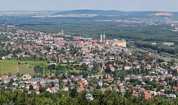
Klosterneuburg [ˈkloːstɐnɔɪ̯bʊʁk] is a town in Tulln District in the Austrian state of Lower Austria. It has a population of about 26,000. The Klosterneuburg Monastery, which was established in 1114 and soon after given to the Augustinians, is of particular historical importance.
It is located on the Danube River, immediately north of the Austrian capital Vienna, from which it is separated by the Kahlenberg and Leopoldsberg hills of the Vienna Woods range. It has been separated from its twin city of Korneuburg on the left bank of the Danube since the river changed its course during the Late Middle Ages. Both towns are connected by a reaction ferry link. The municipal area comprises the northern tip of the Donauinsel as well as the 515 m (1,690 ft) high Mt. Exelberg with its telecommunication tower.
At the site of a former pioneer school of the Austrian Bundesheer, Klosterneuburg has various military buildings and former stores which will be developed into a 12 hectare large new quarter of the town until 2030. It is also the centre of a wine growing area, with several esteemed vintners, numerous Heuriger taverns, and the Federal Institute for Viticulture and Pomology, where the Zweigelt and Blauburger red wine grapes were bred by Fritz Zweigelt.
...
Wikipedia


