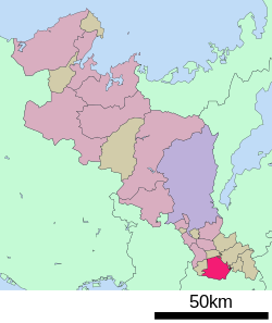
Kizugawa, Kyoto
|
Kizugawa 木津川市 |
||
|---|---|---|
| City | ||
|
||
 Location of Kizugawa in Kyoto Prefecture |
||
| Location in Japan | ||
| Coordinates: 34°44′N 135°49′E / 34.733°N 135.817°ECoordinates: 34°44′N 135°49′E / 34.733°N 135.817°E | ||
| Country | Japan | |
| Region | Kansai | |
| Prefecture | Kyoto Prefecture | |
| Government | ||
| • Mayor | Noriko Kawai | |
| Area | ||
| • Total | 85.12 km2 (32.87 sq mi) | |
| Population (December 1, 2015) | ||
| • Total | 74,054 | |
| • Density | 870/km2 (2,300/sq mi) | |
| Symbols | ||
| • Tree | Cherry blossom | |
| • Flower | Cosmos | |
| Time zone | Japan Standard Time (UTC+9) | |
| City hall address | Kizu Minami-gaito 110-9, Kizugawa City, Kyoto Prefecture (京都府木津川市木津南垣外110-9) 619-0286 |
|
| Website | www |
|
Kizugawa (木津川市 Kizugawa-shi?) is a city located in southern Kyoto Prefecture, Japan. It is the southernmost city in the prefecture and it is named after the Kizu River, a tributary of the Yodo River, which runs through the city. Kizugawa City is a part of the Kansai Science City project and houses research facilities of several corporations, including Rohto Pharmaceutical and Omron.
Kizugawa City is one of the few municipalities in Japan with a growing population. In a population estimate released by the Japan Policy Council, Kizugawa City is the only municipality in Kyoto Prefecture predicted to have a positive population growth rate by 2040.
The modern city was established on March 12, 2007, from the merger of the towns of Kamo, Kizu and Yamashiro (all from Sōraku District).
In the Nara period, Emperor Shōmu moved the capital from Heijō-kyō to Kuni-kyō, which was located on Kizugawa City's ground. Kuni-kyō served as the capital for 5 years from 740 to 744. Its ruins can be found in Kamo area. Now, Kizugawa City is a part of the national Kansai Science City project.
...
Wikipedia


