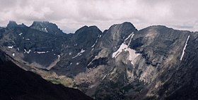
Kit Carson Peak
| Kit Carson Mountain | |
|---|---|
| Kit Carson Peak | |

The Crestones as seen from Mount Adams.
From left to right: Crestone Needle, Crestone Peak, Columbia Point, Kit Carson Peak, and Challenger Point. |
|
| Highest point | |
| Elevation | 14,171 ft (4,319 m) |
| Prominence | 1,025 ft (312 m) |
| Isolation | 1.27 mi (2.04 km) |
| Listing | Colorado Fourteener 23rd |
| Coordinates | 37°58′47″N 105°36′09″W / 37.9797219°N 105.6025089°WCoordinates: 37°58′47″N 105°36′09″W / 37.9797219°N 105.6025089°W |
| Geography | |
|
Location in Southern Colorado
|
|
| Location | Saguache County, Colorado, United States |
| Parent range | Sangre de Cristo Range, Crestones |
| Topo map |
USGS 7.5' topographic map Crestone Peak, Colorado |
| Climbing | |
| Easiest route | Scramble Class 2 |
Kit Carson Peak is a high mountain summit of the Crestones in the Sangre de Cristo Range of the Rocky Mountains of North America. Officially designated Kit Carson Mountain, the 14,171-foot (4,319 m) fourteener is located 5.2 miles (8.4 km) east by south (bearing 102°) of the Town of Crestone in Saguache County, Colorado, United States. The name Kit Carson Mountain is used for both the massif with three summits (Columbia Point, Kit Carson Peak and Challenger Point), or to describe the main summit only. The mountain is named in honor of frontiersman Christopher Houston "Kit" Carson. The Crestones are a cluster of high summits in the Sangre de Cristo Range, comprising Crestone Peak, Crestone Needle, Kit Carson Peak, Challenger Point, Humboldt Peak, and Columbia Point. They are usually accessed from common trailheads.
In January 2002, the Nature Conservancy announced the signing of a $31 million purchase agreement for the Baca Ranch. The purchase significantly expanded the Great Sand Dunes National Park and Preserve in 2004. As part of that complex transaction Kit Carson Mountain was transferred to the Sangre de Cristo Wilderness within the Rio Grande National Forest.
...
Wikipedia

