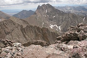
Crestone Peak
| Crestone Peak | |
|---|---|

Crestone Peak seen from Kit Carson
|
|
| Highest point | |
| Elevation | 14,300 ft (4359 m) NAVD88 |
| Prominence | 4554 ft (1388 m) |
| Isolation | 27.4 mi (44.0 km) |
| Listing | |
| Coordinates | 37°58′00″N 105°35′07″W / 37.9666665°N 105.5852865°WCoordinates: 37°58′00″N 105°35′07″W / 37.9666665°N 105.5852865°W |
| Geography | |
|
|
|
| Location | High point of Saguache County, Colorado, United States. |
| Parent range |
Sangre de Cristo Range, Highest summit of the Crestones |
| Topo map |
USGS 7.5' topographic map Crestone Peak, Colorado |
| Climbing | |
| First ascent | 1916 by Eleanor Davis and party |
| Easiest route | Scramble (class 3) |
| Crestone East Peak | |
|---|---|
| Highest point | |
| Elevation | 14,266 ft (4,348 m) |
| Prominence | 80 ft (24 m) |
| Isolation | 0.08 mi (0.13 km) |
| Parent peak | Crestone Peak |
| Listing | Colorado county high points |
| Coordinates | 37°58′02″N 105°35′03″W / 37.96729°N 105.58404°W |
| Geography | |
| Location | Saguache County and high point of Custer County, Colorado, U.S. |
Crestone Peak is the seventh-highest summit of the Rocky Mountains of North America and the U.S. state of Colorado. The prominent 14,300-foot (4,359 m) fourteener is the highest summit of the Crestones and the second-highest summit in the Sangre de Cristo Range after Blanca Peak. The summit is located in the Sangre de Cristo Wilderness of Rio Grande National Forest, 5.0 miles (8.1 km) east by south (bearing 102°) of the Town of Crestone in Saguache County, Colorado, United States.
Crestone Peak rises 7,000 feet (2,100 m) above the east side of the San Luis Valley. It shares its name with the nearby Crestone Needle, another fourteener of the Crestones. The Crestones are a cluster of high summits in the Sangre de Cristo Range, comprising Crestone Peak, Crestone Needle, Kit Carson Peak, Challenger Point, Humboldt Peak, and Columbia Point. They are usually accessed from common trailheads.
...
Wikipedia

